|
©The Archaeological Settlements of Turkey - TAY Project
|
|
|
|
|
 |
Karadere Köprüsü |
|
|
|
|
For site maps and drawings please click on the picture...  |
For photographs please click on the photo... 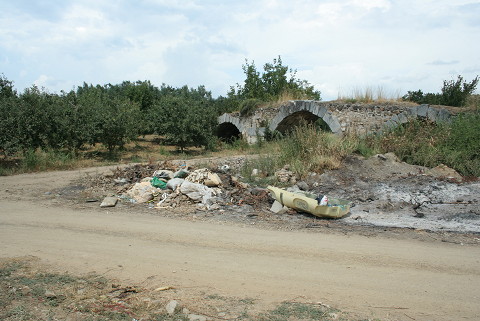 |
|
|
|
|
Type:
|
Bridge |
|
Plan Type:
|
|
|
Year of Costruction:
|
6th c. |
|
Phase:
|
Early Middle |
|
Investigation Method:
|
|
|
Altitude:
|
93 |
|
|
|
|
Region:
|
Marmara |
|
Province:
|
Bursa |
|
District:
|
Iznik |
|
Village:
|
Elbeyli |
|
Antique Name:
|
|
|
|
|
  |
|
| It lies 5 km to the west of Iznik in one of the old stream beds of the Karadere Brook, which spills into the Susurluk Brook after joining the Manyas Mürvetler Stream, originating from the Manyas Lake [Lefort 2003:465-466]. Located on the Gemlik (Chios) - Iznik (Nicaea) motorway, the bridge was built twice due to the displacement of the river bed, once during the Justinian Period, and second probably during the Komnenid Dynasty Period based on its masonry [Kravari 2003:69; Lefort 1995:214-215]. Çakirca Village is 3 km west of the bridge and the Iznik-Orhangazi Motorway is 50 m north of the bridge. The bridge that lies in sotheast-northwest direction is approximately 35 m. Its three arches are observed including the large one in the centervand two smaller ones on both sides. A dirt road passes through the large arch in the center. The field in the southeast of the bridge contains fruit and olive trees and there are reeds and the road in the southeast [TAYEx 29.07.2008]. |
| Location: |
| Geography and Environment: |
| Research and Excavation: |
| Description: |
| Finds: |
| Interpretation: |
| Destruction: The northwest side of the bridge was demolished due to road construction. Besides, there is destruction due to vegetation [TAYEx 29.07.2008]. |

