|
©The Archaeological Settlements of Turkey - TAY Project
|
|
|
|
|
Tasköprü |
|
|
|
|
|
For site maps and drawings please click on the picture...  |
For photographs please click on the photo... 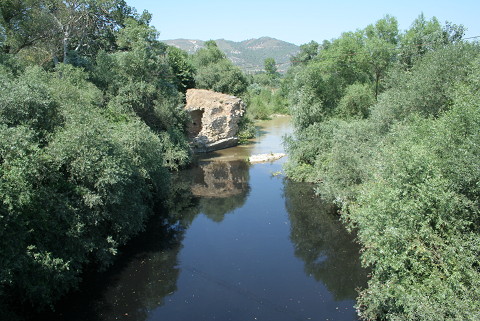 |
|
|
|
|
Type:
|
Bridge |
|
Plan Type:
|
|
|
Year of Costruction:
|
|
|
Phase:
|
Early |
|
Investigation Method:
|
|
|
Altitude:
|
100 |
|
|
|
|
Region:
|
Marmara |
|
Province:
|
Bilecik |
|
District:
|
Osmaneli |
|
Village:
|
|
|
Antique Name:
|
|
|
|
|
 |
|
| The bridge was located near Osmaneli on the Göksu Brook, which is a branch of the Sakarya (Sangarios) River on the Rome-Byzantine road leading from Iznik to Gölpazari. It was either from the Late Roman or Early Byzantine Period. It was also referred by J. Lefort who made a study on the Byzantine roads in Bithynia, however no description is available [Lefort 2003:461-473]. The bridge lies in northwest-southeast direction. A single arch from the bridge remains. Göksu Stream makes a curve southeast of the bridge in southwest direction. The northwest abutment of the bridge arch over the stream was demolished and visible inside the stream. Arch ruins are situated at intervals in southeast direction. The inside and outside surfaces of the bridge contains neatly laid stone blocks. These were filled with rubble stones and lime mortar inside [TAYEx 30.07.2008]. |
| Location: |
| Geography and Environment: |
| Research and Excavation: |
| Description: |
| Finds: |
| Interpretation: |
| Destruction: A large portion was demolished through vegetation and other natural happenings. The plantations around also damaged the remains [TAYEx 30.07.2008]. |