|
©The Archaeological Settlements of Turkey - TAY Project
|
|
|
|
|
|
Liz / Erentepe |
|
|
For site maps and drawings please click on the picture...  |
For photographs please click on the photo... 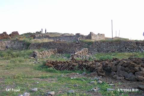 |
|
Type:
|
Mound |
|
Altitude:
|
1660 m |
|
Region:
|
Eastern Anatolia |
|
Province:
|
Mus |
|
District:
|
Bulanik |
|
Village:
|
Erentepe |
|
Investigation Method:
|
Survey |
|
Period:
|
EBA I EBA II |
|
|
|
 |
|
| It lies immediate northeast of Erentepe (Liz) Village; south of the Eren Dere Stream; southwest of Bulanik District; northeast of Mus Province. Soldiers cemetery exists east-southeast of the mound and northwest is the Bulanik-Mus motorway. It is one of the major settlements in the region. It measures 6 m in height and 50 m in diameter. It was investigated by K. Kökten and C.A. Burney. Sherds of the black burnished Karaz ware and the red-brown burnished EBA ware were collected from the surface. Burney reports that EBA I and II finds are found more in the EBA settlements located in the Mus Plain which is actually a closed river-basin. Vast majority of those finds is suggested to be local. The survey carried out under M.S. Rothman exposed that it is the best suitable site to understand the transition from the EBA to the Urartu Period. Erentepe Village will be submerged under the reservoir waters of the Alpaslan Dam. Besides EBA; materials of the second millennium BC; the Urartu Period and the Middle Age are recovered. Also; ruins of a church is visible on the top hill. It takes place in the registered archaeological sites list prepared by Ministry of Culture and Tourism. |
| Location: |
| Geography and Environment: |
| History: |
| Research and Excavation: |
| Stratigraphy: |
| Small Finds: |
| Remains: |
| Interpretation and Dating: |