|
©The Archaeological Settlements of Turkey - TAY Project
|
|
|
|
|
|
Arslantepe |
|
|
For site maps and drawings please click on the picture...  |
For photographs please click on the photo... 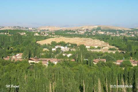 |
|
Type:
|
Mound |
|
Altitude:
|
830 m |
|
Region:
|
Eastern Anatolia |
|
Province:
|
Malatya |
|
District:
|
Merkez |
|
Village:
|
Bahçebasi |
|
Investigation Method:
|
Excavation |
|
Period:
|
EBA I EBA II EBA III |
|
|
|
 |
|
| Location: It is located at Ordüzü Mevkii; northeast of the Malatya Province. At present; Ordüzü Mevkii is a part of the city. The mound Arslantepe (Lions Hill) is named after the lions at the gate which were on the surface even before the excavation started. |
| Geography and Environment: The excavations suggested that the site had been occupied between the Chalcolithic Age and the Late Hittite Period. With its dimensions; 40 m in height and 120x200 m in size; it is one of the biggest mounds of the region. It is surrounded with gardens which are very rich in water. The abundance of water resources played an important role in selecting it as a mainland throughout the ages. It is also located on the trade route running to Central Anatolia from North Mesopotamia via Tohma Valley. |
| History: |
| Research and Excavation: The first researches in Arslantepe was made by L. Delaporte in 1932 to reveal the Late Hittite remains; and lasted until 1939. This was followed by the soundings of C. Schaeffer in 1947-48 to examine the stratigraphy. Excavations were conducted by the hittitologist P. Meriggi from the University of Pavia and archaeologist S. Puglisi in 1961; and were taken over by S. M. Puglisi in 1963 because the epigraphical material was unexpectedly few. After Puglisi; excavations were taken over by A. Palmieri from the University of Roma "La Sapienza"; and they are still being conducted by M. Frangipane [Frangipane 1994a:32-34]. It takes place in the registered archaeological sites list prepared by Ministry of Culture and Tourism. |
| Stratigraphy: As a result of the excavations carried out on the northwestern; western and northeastern slopes of the hill; the settlement stratification is as follows: Late Hittite: Arslantepe level III (1200-900 BC) Late Bronze Age: Arslantepe IV (1600-1200 BC) Middle Bronze Age: Arslantepe V A (2000-1600 BC) Early Bronze Age III: Arslantepe VI D 1-3 Early Bronze Age II: Arslantepe VI C Early Bronze Age I B: Arslantepe VI B-1 and B-2 (3000-2800 BC) Early Bronze Age I A (intermediate): Arslantepe VI A (3300-3000 BC) Late Chalcolithic Age/Local: Arslantepe VII Late Obeid/Intermediate: Arslantepe VIII The last excavators of Arslantepe dated VI A level; which was actually a Late Uruk settlement; to EBA IA (transition period). Therefore, it is regarded as a part of EBA levels in our study. However, the recent studies named this level as Late Chalcolithic (see Chalcolithic / Stratigraphy) [http://www.arslantepe.com/en/stratigraphy/, 2.3.16, 16:27]. According to the finds from 2004 excavation the sequence for Period VIB is now: 1. Destruction of VIA 2. VI B1 arrival of Kura Araxes (Transcaucasian) 3. Royal tomb 4. VI B2 phase 1 fortified settlement (EB I) 5. VI B2 phase 2 village expansion [cat.une.edu.au/page/arslantepe 2006]. |
| Small Finds: Architecture (ascending order): Building Level VI A: At the beginning of EBA I; the rulers of the city used to live in a management center where they could control the raw material and other economic resources and possibly organized the intense economical relations with North Mesopotamia. The building level VI A yielded such a management center covering an area of 2.600 square meters and magnificent buildings. There are two temples built side by side (buildings I and III) and an administrative-public building (building IV) and on the top; multi-roomed buildings inhabited by the managing class. The 2 m high and 1 m thick walls of the buildings are built of mudbricks on a stone foundation. They were whitewashed after being coated with a thick plaster. The larger temple was initially painted in red. The building identified as an administrative or public house consists of an entrance controlling a long corridor flanked with multi-roomed channels on both sides. The rooms serve as distribution; storage; archiving; living and kitchen facilities. They vary in size. There are niches in the rooms. Thousands of clay balls (bulla) were found bearing the seals of the sender thrown all over or stored in several rooms of the building. The abundance of such items indicates the extent the trade developed in that age. It is identical to the trade system at Mesopotamia. Most probably; the system was applied by the people who arrived in Anatolia from that region. M. Frangipane; the last excavator of the site; suggested that this building; considering its characteristics; was a public building [Frangipane 1997:61]. Two schematized figures with triangular heads and big eyes; hourglass-like bodies drawn with black and red paint on a beige background were found in one of the rooms near the entrance. The figures were described sitting at or in front of a table; the wavy lines on their heads depicting the hair [Palmieri-Frangipane 1990:fig.5]. A tree-like drawing behind one of the figures describes the nature. The two buildings on the western terrace; above the terrace this room is located; are suggested to be used for religious purposes. Their building materials and technique are identical. One of the rooms next to the main religious structure was presumably used as a storage room for votives while a little further; the room no. III yielded a metal hoard which will be explained hereinbelow in detail. One of the houses the managing class resided was found in the other trench on the west. It is stated that the house has a multi-roomed structure; but in a distinctive plan than the houses in Mesopotamia. In the 2002 campaign a small sounding was made in the palace corridor; which brought to light a small section of a runoff channel; built entirely of large slabs of stone on all four sides; running underneath the floor and apparently continuing along the whole corridor until it probably ended on the outside of the monumental complex. Palaeobotanical analyses are going to ascertain whether the channel was for rainwater of whether it might have been part of a type of sewerage system [Frangipane 2004:399]. Building Level VI B-1: After the demolition of the building level VI A by a massive fire during a civil war; it is presumed that semi-nomadic tribes used this location in detached order; that they used wood alone as a construction material; lived in wattle and daub huts; the roof plastered by loam; and kept their animal in stables surrounded by fences [Frangipane 1996:65-66]. The period lasted until the last phase of EBA was a recession period for the city. In 2011, an area dated to VIB1 was unearthed on top of the mound. This area separates itself by a fence from the settlement. One (A1045) of the huts is larger than the others. It measures 6x7 m and has at least three renewal phases. In front of the hut, a layer containing animal bones in high density was encountered. The analyses show that these bones belong to goat and sheep. It is possible to suggest that these bones, which were regularly discarded in this area during the all phases of the hut, were the remains of a communal feast. The size of the hut and its location indicates that this structure was used by a "chief" or had a special function. A quite large mud brick building (Building 36) was exposed in the south of the fence that surrounds the large hut. This mud brick building is located immediately below the city wall that was built in VIB2. It lies in the east-west direction. Its north wall extends parallel to the fence. The fact that it shows different architectural characteristics unlike the other ones, which were built in fence-mud technique, and its size point that the building had a communal function or a dominant role in the society. The building has two building levels. Benches and traditional hearths were exposed in both building levels. The first building level has been destroyed due to fire. A large room, a protrusion in the south and passages on both sides were found in the building. These passages provide an access to the room. The room is related to another room in the west. A great number of findings found on the floor and large pots indicate that this room could have been used for storage. In the second building level, the main room of the building was divided into two sections by a thin wall. Fireplaces extending along the south wall were exposed. An area that shows different characteristics was unearthed in the southeast of the mud brick building. This area is surrounded by an irregular wall and a fence. In this area, a plastered oval pit, which contains wooden, and a hut were found. The floor of the hut yielded a large number of anthropomorphic vessels. These findings suggest that the area was used for ritualistic purposes [Frangipane et al. 2014:457-458]. In 2013, the mudbrick city wall was removed and Building 36 was entirely exposed. In previous seasons, it is believed that this building has two building levels. However, it is seen that the building contains three building levels. During the third and latest phase, the function of the building has changed. The main and large room was divided into two small rooms. No traces indicating storing were found on the second floor of the storage room. It is suggested that Building 36 was built around the first phases of 3rd century [Frangipane et al. 2015]. Building Level VI B-2: Right above this level; another phase of poor urbanization; a village consisting of streets cutting each other in right angles flanked by mudbrick buildings on stone foundations on both sides was uncovered. The houses were placed according to the topography of the hill during that age [Frangipane 1996:res.8]. It provides a small example of the typical mudbrick architecture of the Eastern Anatolia region. No monumental structures or buildings were found in the excavated area. In 2004 excavation took place on the upper mound; north of the Period VIA complex. EB II remains were better preserved there but still very disturbed. Good floors were found and suggest a large building with postholes. Both pottery and architecture are of "Gelicik Culture" type. Just under the EB II deposit was a huge 4 m wide fortification wall with buttresses every 3-4 m and rooms added against the buttresses; perhaps after the wall went out of use. This expansion of houses up to the wall is associated with finds of Period VI B2 (EB I) and suggests a more complex sequence for Period VIB than previously realized [cat.une.edu.au/page/Arslantepe 2006]. The 2011 studies show that the large city wall, dated to 2900 BC and located in the north of the palace of VIA, was used during VIB2 as well. At least two building levels of the city wall were determined in this period. The late building level is related to the village settlement that contains mud brick dwellings, stables, workshops, streets and courtyards. The city wall, built with mud brick, sits on stone bases with a width of 5 m. In this late building level, it is not clear whether it was used for defense purposes or not. Mud brick houses were found outside the city wall. Inside the city wall, a few architectural remains were encountered. In the single roomed buildings, which were built adjacent to the outer face of the city wall, hearth, oven and small sized decorated platform were found. A complex containing mud brick rooms were exposed a few meter outside of the city wall. One of the rooms yielded remains indicating metal melting and butchering activities and a hearth. Only 3 rooms were determined inside the city wall. These rooms are contemporary with the buildings outside the city wall. However, they don't belong to the same period with the early building level. During the studies carried out in the city wall, two niches were found among the buttresses. One of these niches gets narrow and continues towards the city wall. It appears to be built to access to the upper section of the city wall. Postholes plastered with mud were unearthed below the buildings of VIB2 located inside and outside of the city wall. These postholes probably belong to temporary dwellings and fences [Frangipane et al. 2014:456-457]. Building Level VI C: In this building level that was dated to the EBA II by the excavator; the settlement size is believed to be comparatively smaller; but consists of big houses with large rooms. Horseshoe-like hearths in clay were found in some of the houses [Frangipane 1993:fig.2]. Arslantepe is; still; the center of the rural settlements in the vicinity during this phase. Building Level VI D: During the last half of the third millennium BC; between 2400 - 2100; the second urbanization phase of Arslantepe starts. It is suggested that the city was not under the influence of Mesopotamia; but came forward with its Anatolian characteristics. The EBA III phase of the city divides into two; IIIa and IIIb. The settlement of EBA IIIa yielded circular structures in semi-subterranean position; the floors at least 1 m underneath the surface of their age. Those structures were entered by going down the stone steps with earth coated banister on both sides. The trenches inside the building are also plastered. Their functions are unclear since no in situ objects were found on the floor. Presences of pillar stones reveal that the roofs were supported with wooden posts. Absence of hearths inside the buildings suggests that those buildings; 2-3.5 m in diameter were not meant for daily life. Lots of semi-circular houses were uncovered [Palmieri 1987:67; fig.1; Frangipane 1992:fig.2]. The remains uncovered on the southwestern slope of the mound and the top hill belonging to the building levels of EBA IIIb yielded huge multi-roomed structures on the terraces; separated by streets. Now; the settlement is in an urban order. The rain collected on the terraces was carried away by a canal system built of stone plates out of the settlement [Frangipane 1991:fig.2-3]. The large houses with multi rooms were furnished with hearths and trenches. The building on the far west of the excavated area is different than the others with its two small basins plastered in the bottom and a short inner stairs. Based on those characteristics; it is suggested to have some other functions. It might be something related with the cult of hunting as twenty goat horns were recovered from another room belonging to a different building level next to this structure. A podium and a round plastered basin found in the small room strengthen this comment. It is just a coincidence that the excavated area did not reveal any building belonging to the ruling class. They are believed to be found in other parts of the hill. It is very obvious that an urbanized society under a sovereign ruler; threatened by foreign enemies; surrounded their city with a monumental fortification wall built of mudbrick on a stone foundation. Only a 42 m part of the fortifications was brought to light on the southwestern foothill. The presence of a round ended bastion gave the city an appearance of a monumental fortress [Frangipane 1996:pic.9]. Pottery (ascending order): The ware imported from North Mesopotamia and examples of Eastern Anatolia were found together in the level VI A dating from the Late Chalcolithic Age-EBA I. The samples of the Late Uruk Period represent this building level. The big size vessels were supposedly employed for storage purposes and the ones with high pedestals for rituals. The presence of wheel-made vessels proves the development of technology. In building level VI B1; this type of ware is replaced by the handmade; black & red burnished vessels [Palmieri 1986:30; fig.3]. There are samples of the reserved slip ware as well [Palmieri 1986:30]. On building level VI B 2; on the other hand; again originating from the commercial relationships; the Uruk Period wheel-made vessels are accompanied with samples of the East Anatolian type "Karaz/Early Transcaucasia" ware. The number of the Nineveh V type samples is poor in this building level dating from the EBA I. In building level VI C dating from the EBA II; Arslantepe has no relation with Syria-Mesopotamia any more. A culture dominated by the painted ware of the Malatya-Elazig area appeared. This culture is thought to be specific to Anatolia. In building level VI D; the painted ware is at its peak. Karaz ware continues. During the studies carried out in 2011 and 2012, potsherds belonging to building level VIB1 were recovered. Two of these potsherds are quite interesting. One of them has incised decoration, while the other one bears relief decoration. Such decorated sherds were also rarely seen in the early period of Kura-Araxes culture. The Building 36 yielded a great number of handmade red-blacked burnished wares and a small number of wheel-made, Syrian-Mesopotamian type light colored wares [Frangipane et al. 2014:458]. The potsherds exposed in Building 36 in 2013 differ from the ones found in other structures. Among handmade dark faced potsherds, there are two narrow-necked bottles, double spouted small jars and two decorated pots. These sherds are unique for Arslantepe VIB1. In addition to these special wares, wheel made, light colored vessels bearing Uruk characteristics, which are not seen in other buildings, were found in Building 36. The existence of wheel made wares in the mudbrick building show the relationship between the nomadic groups of VIB1 and post-Uruk inhabitants in Euphrates Valley and Malatya Plain. This relationship could have been occurred in Building 36 bearing "communal" features [Frangipane et al. 2015]. Clay: Thousands of clay balls (bulla) used to seal the rims of the vessels in order to make sure that the items reach the receiver in exact amount; were found in the building level VI A of Arslantepe. Stamp type seals are more in number than cylindrical seals. The lion figures originating from North Mesopotamia were depicted in a naturalist way. Among others; the king depiction on an ox-cart is interesting. The fact that the storage rooms were sealed separately is understood by the door locks and fragments of clay bearing the traces of the winding string on the lock. The wooden locks are of recessed type [Ferioli-Fiendra 1993:271]. Both building level VI and the other building levels of EBA yielded animal and human figures in terra cotta similar to each other. Chipped Stone: The chipped stone industry of Arslantepe was analyzed by I. Caneva [Caneva 1993:319-339]. Flintstone was used at all building levels more than any other material. The industry is dominated by blades. There are big and long Canaanean blades. Arrowheads are rare in the building level VI B 2 [Caneva 1993:fig.Ia]. Metal: The hoard including nine swords and twelve spearheads found; as if fallen from where it was hanged; among the remains of the building III of building level VI A is an extraordinary find for EBA I. Of weapons; spearheads with a leaf shaped blade; tangled in two-compartments; blade with a quadrangular section were cast in double-mold technique while the short swords with heft and blade were casted in single mold technique. The hefts were decorated with pseudo relief technique by excisions. Three of those swords have inlayed silver decorations of triangles arranged in a row. One of them bears incised fishbone decorations. The quatrefoil spiral plate which is similar to the ones recovered from Troy and EBA III cemetery of Ikiztepe was included in the hoard. All the items worked from arsenical bronze seem to be exceeding the technique and style of their age. The copper included; aside arsenic; a small amount of lead. They are claimed to be hammered hot and cold for further forming following the casting process. The limited number of metal finds recovered from building level VI B-D is insignificant. In the EBA IIIb; to the west of the excavated area; a metal workshop was revealed. The presence of small vessels employed as crucibles and molds in this workshop indicates that the casting process was performed right there. The multi-cavity molds contain casting cavities for flat axes and chisels [Frangipane 1993:88]. During the 2011 and 2012 excavations, in situ copper objects were recovered from Building 36. Two spearheads were found near the north wall of the room in the west. In the protrusion in the south of the main room, four clamps were found together with handmade red-black burnished wares. The clamps have nails. These could have been used to install spearheads to wooden sticks [Frangipane et al. 2014:458]. Two spearheads found in Building 36 in 2012 are similar to the ones recovered from the 4th millennium Palace and the Royal Grave. In 2013, a copper needle with double spirals was found in the storage room of the same building. This needle share similarity to the ones found in Arslantepe Royal Grave and Transcaucasia [Frangipane et al. 2015]. Human Remains: It is suggested that Arslantepe people of the building level VI A-D buried their dead extramurally. The intramural graves house the dead of very important people such as ruler/chief. One of such graves was found undisturbed on the southwest of the hill where the people of the fourth millennium BC used to live [Frangipane 1998:294-296]. The grave was built by standing flat stone plates and capped by a very big single stone. This big stone cracked by itself in time. Bones belonging to four additional burials which were interred together with the chief were found outside the grave [Frangipane1998:294; fig.2]. Two of them were placed west of the grave and the other two right on top of the capping stone. The burials are accompanied with goods such as copper pins; frontons decorated with dots by hammering; two hair-spirals. The grave houses plenty of grave goods. The disarticulated skeleton was in hocker position. Intact vessels which were broken in part; plenty of spearheads with two compartments; sword; flat axe; blade; dagger; pin; ring; earring; fronton and pin with a quadruple spiral (sign of the ruling class) head are among other metal finds. They are made of arsenical bronze; copper; silver; silver-copper alloy and gold (only one piece). Amon intact vessels; there are samples of the handmade; red and black burnished (Karaz) ware and the wheel-made; reserved slip decorated ware and the plain ware [Frangipane 1998:fig.10-11]. The flat stone plates placed on the floors of the grave indicate the neatness during the construction. Fauna: S. Bökonyi's analysis proved that plenty of wild animals were hunted by the people of Arslantepe [Bökönyi 1993:343; tab.1] in a range varying between red deer and wild sheep. In addition to that; bones of the animals which were made part of the flock were found in building levels VI A-D. |
| Remains: |
| Interpretation and Dating: The layer VI A of Arslantepe became the scene of a settlement under the urbanization process; with its monumental buildings and the economy system of Mesopotamia. In this layer; the inhabitants were involved in the production and control of metals. It is suggested that this society probably dominated the local people with their metal and textile technology. The ruling class possibly of Mesopotamian origin came to the Malatya area to acquire raw material resources. The increase in the sheep bones in this level relate to the development of a textile industry. The traces of specialization in grain production can also be observed. The presence of grape seeds in one of the silos of VI A palace may be a sign that the wine production started in this period. The settlement in Arslantepe decreased in size after the second quarter of the EBA; and then regained its urban identity in the second half of the third millennium BC. The mound reached its current size during this period. The presence of a fortification wall in the last phase of the EBA is evidence that the inhabitants lived under sovereign rule. The fortress-like city; now; has all the characteristics of an Anatolian trade system. Even though the palace of the city was not revealed; the presence of the metal casting workshop; the fortification wall; and a room for sorcery proves the existence of a social stratification and craftsmanship. Although it can not be clarified if Arslantepe was the capital of the Malatya region during that period; it can be suggested that it was a significant city based on its situation in the first millennium BC. Furthermore; it can be claimed that the name Melitene derives back to the third millennium BC. |