|
©The Archaeological Settlements of Turkey - TAY Project
|
|
|
|
|
|
Sadikbey |
|
|
For site maps and drawings please click on the picture...  |
For photographs please click on the photo... 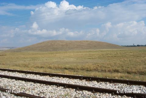 |
|
Type:
|
Mound |
|
Altitude:
|
1080 m |
|
Region:
|
Aegean |
|
Province:
|
Afyonkarahisar |
|
District:
|
Merkez |
|
Village:
|
Sadikbey |
|
Investigation Method:
|
Survey |
|
Period:
|
EBA II |
|
|
|
 |
|
| It lies 500 m west of Sadikbey Village; some 8 km northwest of Afyonkarahisar Province. West of the mound passes the railroad. It is included in the map of the Afyon Archaeological Museum. It was discovered by J. Mellaart. It is an EBA II settlement. The site was re-documented in 2005 during the fieldwork of Phygrian Valley Tourism Zone Project. It is also known as Küçük Corca Höyük. It takes place in the registered archaeological sites list prepared by Ministry of Culture and Tourism. |
| Location: |
| Geography and Environment: |
| History: |
| Research and Excavation: |
| Stratigraphy: |
| Small Finds: |
| Remains: |
| Interpretation and Dating: |