|
©The Archaeological Settlements of Turkey - TAY Project
|
|
|
|
|
|
Samsin |
|
|
For site maps and drawings please click on the picture...  |
For photographs please click on the photo... 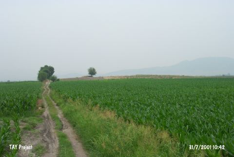 |
|
Type:
|
Mound |
|
Altitude:
|
70 m |
|
Region:
|
Mediterranean |
|
Province:
|
Osmaniye |
|
District:
|
Kadirli |
|
Village:
|
Koçyurdu |
|
Investigation Method:
|
Survey |
|
Period:
|
Ceramic |
|
|
|
 |
|
| Location: This site lies northeast of the city of Adana; 15 km south of the town of Kadirli; 4 km east of the Ceyhan-Kadirli highway; along the dirt road that goes to the villages of Koçyurdu (Endel) and Eskiler. |
| Geography and Environment: The mound lies along a road; on the flanks of the Anti-Taurus Mountains. It is an oval-shaped mound which is 50x70 m in diameter and 7 m high. |
| History: |
| Research and Excavation: The mound was discovered in 1951 by M.V. Seton-Williams. It was researched in 1961 by the French Archaeological Institute. |
| Stratigraphy: In addition to Neolithic finds; surface surveys on the site also yielded Chalcolithic and Hittite finds. |
| Small Finds: Pottery: The ceramics resemble Cilician Late Neolithic Ware and especially Mersin Yumuktepe types [Seton-Williams 1954:128]. Chipped Stone: Flint and obsidian tools and debitage products were found. No other information has been provided on the chipped stone finds. |
| Remains: |
| Interpretation and Dating: The site; which has been assigned to the Late Neolithic by Seton-Williams; has also been listed among Cilician Neolithic sites by Mellaart. Todd; on the other hand; treats these interpretations with acertainty [Todd 1980:144]. In ASPRO; the site has been placed in the sixth phase (uncalibrated dates are 7;600-7;000 BP) Provisionally the site is dated to the Late Neolithic. |