|
©The Archaeological Settlements of Turkey - TAY Project
|
|
|
|
|
|
Tirmil Tepe |
|
|
For site maps and drawings please click on the picture...  |
For photographs please click on the photo... 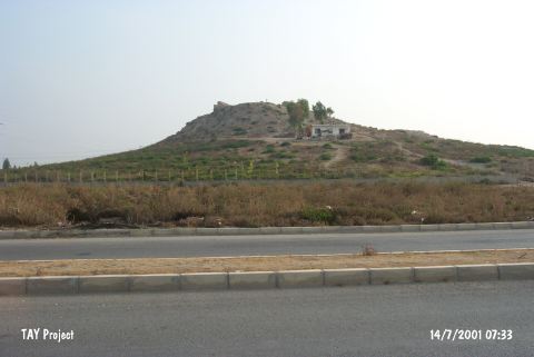 |
|
Type:
|
Mound |
|
Altitude:
|
140 m |
|
Region:
|
Mediterranean |
|
Province:
|
Mersin |
|
District:
|
Merkez |
|
Village:
|
Çilek |
|
Investigation Method:
|
Survey |
|
Period:
|
|
|
|
|
 |
|
| It lies in Çilek Quarter; on the railway running from Mersin to Tarsus; northeast of Mersin Province. There is a lowland of 30 m on the top hill. It is 12 m high. On the foothill lies a modern village. The mound is also called Turmil or Termil. The Middle Age castle rising on the top is reported to be; probably; called Kale-i Habelleç. The surface collection carried out during the Cilicia survey in 1951 yielded sherds varying from the Chalcolithic Age to the Islamic Period. Samples of the red and black burnished ware are evaluated as EBA productions by M.V. Seton-Williams. |
| Location: The site lies in Çilek Quarter; northeast of the city of Mersin; and north of the Mersin-Tarsus highway and railroad tracks. The mound can be found on a 1:200;000 map. |
| Geography and Environment: The mound that is also known as Turmil or Termil is 12 m high and has a 30 m diameter. The top part of the mound is flat. Modern buildings have been built on the slopes of the mound. There are stone ruins of a late period structure on the top of the mound. Since the site lies on a trade route; the ruins are believed to have been a stop for travelers. This site is believed to be where the Kale-i Hebelleç castle; which lies between the Mersin and Tarsus; is located. |
| History: |
| Research and Excavation: |
| Stratigraphy: |
| Small Finds: |
| Remains: |
| Interpretation and Dating: |