|
©The Archaeological Settlements of Turkey - TAY Project
|
|
|
|
|
|
Aziziye |
|
|
For site maps and drawings please click on the picture...  |
For photographs please click on the photo... 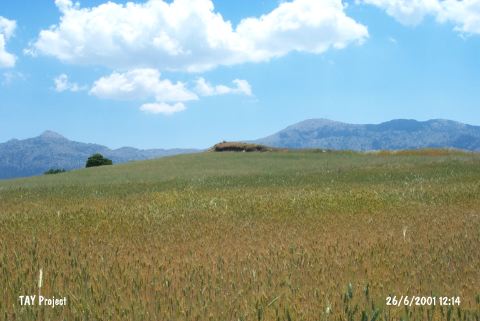 |
|
Type:
|
Mound |
|
Altitude:
|
1220 m |
|
Region:
|
Mediterranean |
|
Province:
|
Burdur |
|
District:
|
Merkez |
|
Village:
|
Aziziye |
|
Investigation Method:
|
Survey |
|
Period:
|
|
|
|
|
 |
|
| It lies in Höyük Mevkii; 600 m west of Aziziye (Çamoluk-Sertaç) Village; south of the city of Burdur. It is also located 10 km south of Gölde and 2 km south of the village of Erikli. To the south of the mound lies the Kocademir Stream; one of the branches of the Elmacik Stream. It measures 150x250x8 m. During the survey conducted by M. Ozsait in 1983; pottery dating from the EBA and the Early Chalcolithic Age was collected from the surface. It takes place in the registered archaeological sites list prepared by Ministry of Culture and Tourism. |
| Location: This site lies in Höyük Mevkii; 600 m west of Çamoluk (Aziziye-Sertaç) Village; south of the city of Burdur. It is also located 10 km south of Gölde and 2 km south of the village of Erikli. |
| Geography and Environment: This mound; which is 150x200 m in size; lies 1;100 m above sea level and 8 m above the level of the plain [Özsait 1989a:chart.XIV; fig. 5]. Kocademirli Stream; one of the branches of Elmacik Stream; flows south of the mound. The area has abundant sources of water. The mound lies in the Elmacik-Kozluca municipality along the Kocademirli-Elmacik highway. The surface of the mound has been plowed. |
| History: |
| Research and Excavation: |
| Stratigraphy: |
| Small Finds: |
| Remains: |
| Interpretation and Dating: |