|
©The Archaeological Settlements of Turkey - TAY Project
|
|
|
|
|
|
Ulucak Höyük |
|
|
For site maps and drawings please click on the picture...  |
For photographs please click on the photo... 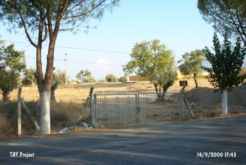 |
|
Type:
|
Mound and Cemetery |
|
Altitude:
|
220 m |
|
Region:
|
Aegean |
|
Province:
|
Izmir |
|
District:
|
Kemalpasa |
|
Village:
|
Ulucak |
|
Investigation Method:
|
Excavation |
|
Period:
|
Ceramic |
|
|
|
 |
|
| Location: It lies 150 m north of the Bornova-Turgutlu-Ankara motorway at 15th km; 7 km northwest of Kemalpasa; east of the Bornova District and the Izmir Province. It is about 400 km north of the old Izmir-Kemalpasa road and 1 km south of Ulucak village. To the immediate south lies the tobacco factory of Socotap. The cemetery is located 150 m southeast of the mound in the garden of this factory [Derin-Özkan 1999:plan1]. The road parting from the motorway to the village of Ulucak passes by the west side of the hill. The cemetery is partly obscured by the motorway. |
| Geography and Environment: It is a round and flat mound located in a plain; 5 m in height and 90 m in diameter [French 1965b:18]. The settlement is suggested to measure larger. The southern and eastern parts of the hill have been partly damaged by the road and the environmental arrangement factories. The mound gets lower toward the north. The plain of Kemalpasa formed a fertile land around the mound by the accumulation of alluvial brought by the waters running from the high mountains in the vicinity. The plain is separated from the shore plain of Bornova by the threshold of Belkahve. The settlement is reported to be located on the natural transportation road between Central Anatolia and the Gulf. The mound is said to locate at the foothill of an old accumulated conic hill [Derin-Öner 1997:412]. The cemetery has been partly damaged during the construction of the factory. A small stream flows about 400 m south; parallel to the road. It is reported that the site was cultivated at during the researches. Together with the excavations; palaeogeographical investigations including the mound and its surroundings were also started under the leadership of I. Kayan from the Geography Department of Ege University; and it was understood that the mound once expanded over a much larger area. |
| History: |
| Research and Excavation: It was introduced by D.H. French [French 1969:55]. A survey was carried out by R. Meriç [Meriç 1989:387; Meriç 1990:362]. It was excavated from 1995 to 2002 by Z. Derin under the consultation of A. Çilingiroglu. The excavation was taken over by E. Abay; H. Saglamtimur and T. Özkan in the recent years. The palaeogeographical surveys of the settlement and its surrounding territory are carried out in parallel to the excavations. Soil samples were taken by carrot in the vicinity. The cemetery was also started to be excavated in 1998 in parallel to the excavation by the University of Ege and the Izmir Archaeological Museum. The site was revisited and investigated by a team under Z. Derin during the fieldwork of Bornova-Kemalpasa (Izmir) Archaeological Inventory. The mound was dug by a team under the leadership of A. Çilingiroglu in 2005. It takes place in the registered archaeological sites list prepared by Ministry of Culture and Tourism. The excavations are lead by Ö. Çevik from Trakya University since 2009. |
| Stratigraphy: Including the 2005 excavations; the Ulucak Höyük Stratification is as follows: I. Late Roman-Early Byzantine: a; b; c II. Early Bronze Age (II): a; b 1/2 III. Late Chalcolithic IV. Neolithic: a; b 1/2; c; d; e; f; g; h; i; k V. Neolithic a; b [Çilingiroglu-Dedeoglu 2007:142]. 2006 radiocarbon dates for VB phase are 6400/6200 BC, and there is still 4 m of cultural deposit below. Phase Ve belongs to the early 7th millennium. 2007 radiocarbon dates show these levels date back to the 7th millennium BC. Dates for Level 4 are 5990-5730, 6030-5895 and 6055-5885 BC, while Level 5 has dates of 6230-6055, 6430-6240 and 6660-6450 BC. [http://cat.une.edu.au/page/ulucak%20hoyuk-kemalpasa; 16.11.2009, 15:10]. In previous studies, Level VI was assigned to Early Neolithic and Level V was dated to Late Neolithic. However, the data obtained from recent studies and radiocarbon dates show that it would be more accurate to define Level VI, which yielded no findings including pottery, as Proto Neolithic. In addition, it was suggested that Level V, which is characterized by wattle and daub and piled mudbrick architecture, should be dated to Early Neolithic and Level IV, which is represented by mudbrick architecture, should be assigned to Late Neolithic [Çevik-Vuruskan 2015:583]. |
| Small Finds: Architecture: The buildings were constructed in the northeast-southwest direction; in three rows towards east and generally with common walls. The eastern buildings on the third row are separated from the second row with a narrow road. The buildings on the western side are higher than the ones on the eastern side. According to this; it was understood that the buildings to the east of the mound were constructed leveled; as they can expose the light due to the inclination. Two different techniques were used for the construction of the walls. While the majority of the walls were built using mudbrick; the others were constructed by plastering mud on wood and tree branches. Most of the buildings have stone foundations. All of the mudbricks on the stone foundations measure 30x35 cm and were mostly fired during the fire. The pise technique was generally applied on the garden and separation walls. The dense fire remains on the floors has shown that the Late Neolithic Period ended with a massive fire. According to the neat construction; location; brown wall paintings consisting of dots and wavy lines on the wall plaster around the hearth of one of these burnt buildings; it is suggested that this structure might have been used for a special purpose [Derin et al. 2002:342-344]. In building level IVb1; the floors of the previous level were restored and continued to be used. Additions were made to several buildings. The walls of building No.19; which were constructed with pise technique; were collapsed both inside and outside of the building as a result of a massive fire or earthquake. To the east of this building is a 2.60 m wide courtyard with a compacted soil floor. Numerous architectural features related to domestic usage were encountered in this courtyard. In the burnt layer found in this level; burnt wood remains were found close to each other. According to the burnt seed/grain examples and a mortar stone; it is suggested that there was a wooden grain chest in this area and the room was used as a pantry. To the west of the buildings No.1 and 2 is a channel filled with ashy soil. It runs in the northwest-southeast direction. The channel's floor is made with compacted soil; and measures 8.50 m in length and 0.60 m in width. A regular architectural plan is observed in building level IVb2. A total of 13 buildings; 2 courtyards and 2 streets. The buildings were arranged in three levels in north-south direction. They are connected to the streets and the doorways are placed facing to the street. building No.19 was constructed using mudbricks on stone foundations; its floor and walls were plastered. The courtyard is reached by a 80 cm wide doorway on the western wall. Building No.13 has two rooms and in a location close to the eastern sides of each room were found furnaces and hearths. The architectural remains of building level IVc is only represented by floors and the remains found on them [Derin-Çilingiroglu 2003:186-189]. The cultural soil layer of layer Vb; accessed during 2005 excavations is approximately 25 cm thick. The layer frequently reveals burnt rubble clay. The excavations helped unearthing three rooms named 27; 28; and 29 [Çilingiroglu-Dedeoglu 2007. 138]. All the walls of the room 27 were found except for the southern wall. The wall is approximately 20 cm wide. Seven holes for wooden poles were found inside the square shape walls of the room which are 10 cm in diameter. Wooden poles were erected for building the walls and those were covered with mud. Although there are remains of plaster inside the buildings the external surfaces of the houses could never be detected. There are five silos used for storage purposes found inside the building. Two of the silos were based on the northern wall; and one on the eastern wall. Another silo was found inside the southern wall. There is a large kiln inside the northern wall; which was highly destructed. An ash collector is at the east of the kiln. There are three seriously destructed benches or seating rows on the southwest of the kiln which could be architectural furniture. It is found that the building has a plastered floor [Çilingiroglu-Dedeoglu 2007:138-139]. Building 28 is in the north of the building 27. There is a 1.20 m wide gap between them. The wall width was measured 0.15 m at the section that was found. Although there is no plaster remain on the walls the plaster on the internal and external surface of the southern wall was partially preserved. It is found that the building has a plastered floor [Çilingiroglu-Dedeoglu 2007:139 - 140] The building 29 is on the east side of the building 27. Out of the five holes for wooden poles that could belong to the building's walls; four are in the south; and one in the west. But the remains of clay was found neither at the cross-section; nor in the holes for the wooden poles. Possibly the wall was completely destroyed. There is a workshop found on the east corner of the building where there are a lot of tools in situ [Çilingiroglu-Dedeoglu 2007:140]. In Level Vb one-roomed houses of square shape were found in 2006 studies [[http://cat.une.edu.au/page/ulucak%20hoyuk-kemalpasa; 16.11.2009, 15:10]. In 2007, in Level 5b and below there is less use of mud brick and stone foundations, and when they occur they are less well preserved. Wooden structures may have been more common in these levels and postholes were identified in a hard surface of Level 5c. The houses maintained the same orientation and area over a long time. Level 5d consists of very hard, clayey earth with no architectural remains [http://cat.une.edu.au/page/ulucak%20hoyuk-kemalpasa; 16.11.2009, 15:10]. During the studies carried out in 2011, the last phase of Level V, which is called Vf, that is dated to Late Neolithic was exposed. The Phase Vf represents the earliest phase with pottery in the mound. This phase comprised of the walls, floor, pits and hearth floors belonging to the structure numbered 40 [Çevik 2013:147]. Level VI dated to Early Neolithic is characterized by Space 42 with red colored lime floor, Space 43 and hearth related to these spaces. Space 42 is located on the west of Trench L13. Only the north and south walls of Space 42 were exposed. These walls measures about 20-25 cm in width. On the red colored lime floor of the space, in front of the west section of the trench, lime plastered debris painted in red covering an area of 3.70x2.40 m was found. There is a posthole with a dimension of 15x17 cm which is probably used for supporting the roof on the floor. The floor of the space was formed was covered with pebbles and then plastered with lime and finally painted in red. The floor has been plastered three times and in every phase all of the process was repeated including the pebble paving. One goat jaw with its teeth, one bone spatula and one flint blade were found on the floor of Space 42. The exposed part of Space 43 that is situated directly on the virgin soil covers an area of about 24 square meters. The walls of this structure were probably erected with wattle and daub technique as well. Contrary to Space 42, it has one phase. The floor was made in the same way as in Space 42. Two hearths were found. One of them is located on the southeast corner of the structure and the other one is recovered on the area that joins the north section. A fill which contains most probably lime with a width of 1.90 m, a length of 4.67 m and a height of 8 cm was exposed on the east of the space. This fill probably extends towards the east section of the trench. One bone tool in the form of a fork, a few worked bones, one stone bead and animal bone in small quantities were found on the floor of Space 43 [Çevik 2013:147-150]. During the 2012-2013 studies, Neolithic levels were excavated in 6 trenches in total. Level IV, which is Late Neolithic (6000-5700 BC) is one of the most well preserved levels. This level was largely investigated. In 2013, remains of room and a street in its south belonging to this level were exposed. The room (Room 12) in the north of of Trench O13 covers an area of 50 square meters. The walls of the room are preserved up to 2 m. The inner and outer surfaces of walls are plastered and these walls are built on three rows of mudbrick. Their thickness is 50 cm. The floor of the room is compacted soil. The room is accessible through a door with a dimension of 1.60 m located in the center of its west wall. Inside the room, an oven and a bench were found. The opening that is located between Room 12 and a wall belonging to another room is regarded as a street and it is 1.30 m in width. The floor of this opening is paved with pebbles. In this street, anthropomorphic figurines, bone awl, stone axe and sling stone were found at the various elevations. In the northern slope of the mound, Late Neolithic levels of Trench L12 have been damaged due to the remains belonging to Roman Period on top of it. In this area, two building levels (Va and Vb) of Early Neolithic (Level V) were determined. The building level Va is represented by a room (Room 46) and a street located in its west. The vast majority of Room 46 remained in the section. The excavated section measures 2.04x1.85 m. Postholes were found on the northwest and northeast walls of the room. This data indicates that the walls were built in wattle and daub technique. A posthole with a diameter of 12 cm was exposed in the center of the room. The thickness of the walls ranges from 28 cm to 31 cm. The inner surface of the walls is plastered. Although the floor has not been properly preserved, it should be compacted earth floor. In the west of Room 46, the pebbled surface extending in the southwest-northeast direction was defined as street. The street measures 8.50x1.80 m. A large number of potsherds and bones and flint, obsidian tools were found in the area. The building level Vb is represented by two rooms (Room 51 and Room 47). Room 51 is located under Room 46. The excavated section of Room 51 measures 3.10x2.30 m. The lack of the postholes on the wall indicates that this room was built with piled mudbrick. Room 47 measures 2.80x2.36 m. The walls were built pise or piled mudbrick. In the earliest level, Level VI (Pre-Neolithic Period), Room 42 and 43, which have red colored lime plastered floor, and the floors of hearth and ovens in the south were found. These remains are located in the northern slope of the mound. In 2012, 13 floors belonging to oven and hearth were exposed in this level. These remnants have three phases [Çevik-Vuruskan 2015]. In 2014, the studies were carried out in the trenches that opened in the previous seasons. In Space 52 in Trench O13, a floor belonging to an oven, the upper section of which was severely damaged due to a heavy fire, was exposed 0.50 cm high from the floor in front of the north wall. In Trench K13, oven-hearth floors and ashy areas were found. It is found out that these remains related to an external space rather than an internal space. The studies were also conducted in Trench L12 in Level Vb. The room is accessible through an opening in the west. The floor is made out of compressed earth. The room contains a platform in front of the north wall and a round hearth in the south, and another hearth in the east. Due to the massive fire, the upper structure of the room was severely damaged. The room also yielded three clay siloi and a clay box in rectangular shape. There are 8 irregular postholes on the floor of the room. During the studies carried out in Space 53 in Level Vf, only the wall (built with compact mud brick) in the southeast preserved due to the heavy destruction. The room has also a compressed earth floor. There is a shallow silo, plastered with lime, on the floor in the east section. A hearth with a pebble-paved floor was found in the southwest of the silo. Wheat remains were found in the clay burnt layer taken from the room. The radiocarbon analyses indicate the dates of 6505-6440 BC [Çevik et al. 2016:270-272]. Pottery: The Plain Burnished Ware found in the Neolithic sites in the Manisa region was found on this mound as well. This ware is handmade and the clay has a lot of chaff temper. The most common vessel types are bowls and jars. The surfaces of these ceramics have been treated either with red or occasionally black/gray slip or have been burnished. The ceramics found during the excavation generally have brown; red-brown and cream clay; and red-brown and brown slip. The ceramics; which are thin walled and hardly fired; have sand; grit and plant temper. Rolled out S profiled bowls; simple carinated bowls and jars; oval bodied and based bowls; vertical pierced lugs and loop-handles were found. An anthropomorphic vessel with painted decoration and a few vessels with painted; jagged and notched decorations were also encountered [Derin et al. 2002:344]. Sherds were found in building 27 during the 2005 excavations; and two complete vessels inside the building 28 [Çilingiroglu-Dedeoglu 2007:139-140]. 2006 pottery findings are red burnished with vertical tubular handles and is undecorated [http://cat.une.edu.au/page/ulucak%20hoyuk-kemalpasa; 16.11.2009, 15:10]. In 2007 studies, the pottery tradition continues unbroken from Level 5e to Level IV. No complete vessels were preserved but there was a good quantity of pottery, especially in Level IV. Most has a red slip but a coarser, darker ware with thicker walls also appeared.[http://cat.une.edu.au/page/ulucak%20hoyuk-kemalpasa; 16.11.2009, 15:10]. The potsherds found in 2011 are in high quality though in small quantity. Along with the red, cream slipped and burnished wares; this phase is characterized by dark brown colored, burnished wares and vessels with mica temper [Çevik 2013:147]. Late Neolithic wares found during the 2012-2013 excavations consist of red, cream and brown slipped wares. Among the forms, necked jars, short-necked jars, S profiled bowls and jars are common. There are also a few sherds with impresso and paint decoration [Çevik-Vuruskan 2015:589]. 3 almost whole vessels were found in Trench O13 during the 2014 studies [Çevik et al. 2016:270]. Clay: Terra cotta goddess figurines were found. Their height measures between 2.2-6.6 cm. It was understood that the headless figurines with the arms holding the breasts from the under were actually shaped standing; with huge hips and flat backs. The upper part of their bodies are triangular and their arms are short and thick [Derin et al. 2002:345]. Baked clay weights and tokens measuring about 2 cm; which were probably used for economical activities; were also encountered. The flat idol with textile fiber on it; that was found in building 27 during the 2005 excavations is considered to be an important find [Çilingiroglu-Dedeoglu 2007:139]. Other 2006 finds include clay sling balls and two clay stamps [http://cat.une.edu.au/page/ulucak%20hoyuk-kemalpasa; 16.11.2009, 15:10]. The 2014 studies yielded: 9 sling stones and one spindle whorl from Trench O13; 64 baked clay sling stones (together with the noes found in 2013), 6 baked clay spindle whorls, and 3 baked clay tokens from Trench L12 [Çevik et al. 2016:270-271]. Chipped Stone: Chisels; perforators and scarpers made of flint and obsidian were encountered. There are many flintstone; and obsidian blades; piercing tools; and scrapers found during the excavations in 2005 [Çilingiroglu-Dedeoglu 2007:139-141]. Ground Stone: Stone tools such as mortars and pestles; polishing stones; slingstones and stone axes were found. In 2014, 4 stone axes, 5 grinding and ground stones, 8 pestles, and 4 burnishing stones were found in Trench O13 [Çevik et al. 2016:270]. Human Remains: In 2012, two simple earth graves were found in the area where the floors of oven and hearth belonging to Level VI are exposed. These graves contain infant burials. One of them is 38 weeks old and the other one is 40 weeks old. The orientation of these burials is not clear because of the damage [Çevik-Vuruskan 2015:593]. Fauna: The 2014 studies yielded: a few bone tools from Trench O13; 8 bone tools from Trench L12. Also, animal bones were recovered from the hearth in Space 53 in Trench K13. The radiocarbon analyses indicate the dates of 6695-6630 BC [Çevik et al 2016:270-272]. |
| Remains: |
| Interpretation and Dating: The first analysis of the Ulucak Höyük Late Neolithic pottery has shown that the inhabitants of this settlement had relations with the settlements of the Balkans; Aegean coast and Central Western Anatolia. However; the general characteristics of the culture seems to be more related to the Western Anatolia cultures rather than the Balkans; Aegean Islands and Greece continent. The concrete archaeological evidence indicates relations with Burdur region; some vessels found in Hacilar IV; Kuruçay 11-7; Höyücek Temple Phase and Bademagaci 1-2 layers have similarities with the Ulucak ceramics. There were many sea shells found inside and around of some vessels found during the 2005 excavations. The fact that sea products were used as nutrition in EBA was also the case in Neolithic Age emphasizes the connection of the settlement with the marine culture [Çilingiroglu-Dedeoglu 2007:140]. The presence of storage jars or storage boxes in Vb phase was admitted as the sign of success in agricultural production. Especially the dressed flat figurine; and two seals (press mould ?) are important. The radio carbon results revealed from this layer showed that the settlement in the mound goes back to 6400 BC; for now [Çilingiroglu-Dedeoglu 2007:140]. |