|
©The Archaeological Settlements of Turkey - TAY Project
|
|
|
|
|
|
Ulucak Höyük |
|
|
For site maps and drawings please click on the picture...  |
For photographs please click on the photo... 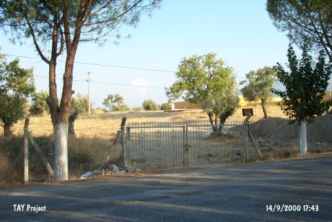 |
|
Type:
|
Mound and Cemetery |
|
Altitude:
|
220 m |
|
Region:
|
Aegean |
|
Province:
|
Izmir |
|
District:
|
Kemalpasa |
|
Village:
|
Ulucak |
|
Investigation Method:
|
Excavation |
|
Period:
|
EBA II |
|
|
|
 |
|
| Location: It lies 150 m north of the Bornova-Turgutlu-Ankara motorway at 15th km; 7 km northwest of Kemalpasa; east of the Bornova District and the Izmir Province. It is about 400 km north of the old Izmir-Kemalpasa road and 1 km south of Ulucak village. To the immediate south lies the tobacco factory of Socotap. The cemetery is located 150 m southeast of the mound in the garden of this factory [Derin-Özkan 1999:plan1]. The road parting from the motorway to the village of Ulucak passes by the west side of the hill. The cemetery is partly obscured by the motorway. |
| Geography and Environment: It is a round and flat mound located in a plain; 5 m in height and 90 m in diameter [French 1965b:18]. The settlement is suggested to measure larger. The southern and eastern parts of the hill have been partly damaged by the road and the environmental arrangement factories. The mound gets lower toward the north. The plain of Kemalpasa formed a fertile land around the mound by the accumulation of alluvial brought by the waters running from the high mountains in the vicinity. The plain is separated from the shore plain of Bornova by the threshold of Belkahve. The settlement is reported to be located on the natural transportation road between Central Anatolia and the Gulf. The mound is said to locate at the foothill of an old accumulated conic hill [Derin-Öner 1997:412]. The cemetery has been partly damaged during the construction of the factory. A small stream flows about 400 m south; parallel to the road. It is reported that the site was cultivated at during the researches. Together with the excavations; palaeogeographical investigations including the mound and its surroundings were also started under the leadership of I. Kayan from the Geography Department of Ege University; and it was understood that the mound once expanded over a much larger area. |
| History: |
| Research and Excavation: It was introduced by D.H. French [French 1969:55]. A survey was carried out by R. Meriç [Meriç 1989:387; Meriç 1990:362]. It was excavated from 1995 to 2002 by Z. Derin under the consultation of A. Çilingiroglu. The excavation was taken over by E. Abay; H. Saglamtimur and T. Özkan in the recent years. The palaeogeographical surveys of the settlement and its surrounding territory are carried out in parallel to the excavations. Soil samples were taken by carrot in the vicinity. The cemetery was also started to be excavated in 1998 in parallel to the excavation by the University of Ege and the Izmir Archaeological Museum. The site was revisited and investigated by a team under Z. Derin during the fieldwork of Bornova-Kemalpasa (Izmir) Archaeological Inventory. The mound was dug by a eam under the leadership of A. Çilingiroglu in 2005. It takes place in the registered archaeological sites list prepared by Ministry of Culture and Tourism. The excavations are lead by Ö. Çevik from Trakya University since 2009. |
| Stratigraphy: The Ulucak Höyük Stratification is as follows; including the 2005 excavations: I. Late Roman-Early Byzantine: a; b; c II. Early Bronze Age (II): a; b 1/2 III. Late Chalcolithic IV. Late Neolithic: a; b 1/2; c; d; e; f; g; h; i; k V. Neolithic a; b [Çilingiroglu-Dedeoglu 2007:140]. |
| Small Finds: Architecture: Excavations of Ulucak Höyük lasted until 1998 yielded walls of houses and terraces belonging to EBA. Although walls in parallel to each other were uncovered; it is unclear to what building they belong due to the severe damage. Two walls in parallel to each other among the house walls built of medium-sized quarry stones uncovered in the building level 2 can be suggested belonging to the same building. The thickness of the wall is 90 cm. Other walls are in different direction. A wide wall extending in the north-south direction was uncovered in the building level 3. It is probably a terrace wall. Another wall of 50 cm thick was uncovered erected by the same technique. The architectural plan is expected to be clearer as the excavations progress. The brown culture soil containing clay that is accessed following layer 1; represents EBA II. The row of stones in noorthwest-southeast direction belongs to a building approximately 4.50x3.00 m in size. The presence of a doorway stone on the same level as the northwest wall shows that there was an entrance that belonged to this building. On one side the building 30 has three walls as the northern; eastern; and western walls; with a neat masonry; on the other side the southern wall is completely scattered. The rectangular building resembles a megaron type of building [Çilingiroglu-Dedeoglu 2007:141]. Square planned EBA II buildings in very bad condition were found inside the trenches that expanded towards the north during the researches in 2006 [http://cat.une.edu.au/page/ulucak%20hoyuk-kemalpasa; 29.5.2008; 16:40]. In 2011, EBA level is represented by a compressed floor which was paved pebble stones in patches. This floor extending towards the south side of Trench P13 was exposed in front of the northwest section of Trench R13 [Çevik 2013:147]. Pottery: EBA layer yielded handmade; burnished ware with a gray; black; brown; and buff paste and wash datable to EBA II for Z. Derin [Derin-Öner 1997:416-417; draw.8-15]. Forms of plates; bowls; jugs and spouted pitchers are common. Some vessels are attached pierced trumped lugs. Derin and Öner state that the carinated bowls with unrolled rims are characteristics of EBA II [Derin-Öner 1997:417]. The vessels are plain; and no decorated ware was found. In 2011, a whole red slipped and burnished depas was found on the compressed floor in Trench R13 [Çevik 2013:147]. Clay: Sling pebbles; spindle whorls and toy wheels were recovered [Abay et al. 2000:360]. Bone/Antler: A perforator in bone was recovered [Derin-Öner 1997:draw.16]. Other: Stone axes (flat axe) and plenty of flint blades were found. Some of the mussel shells were worked for ornaments by perforating. Human Remains: An extramural; not far from the settlement; cemetery was established by interring the pithoi into the pits opened in the former flooded bed of the Nif Stream. It was used during both EBA and MBA. The burials interred into the pithoi and big jugs of 1-1.5 m high were contracted before their body became harder following the death; and their arms were combined over the breast as to put their hands below the head. In hocker position; the dead was buried into the pithos; head oriented toward the opening. The pithoi were placed in order in an area of 30 m in diameter. Yet; it is clear that the burial procedure was not planned as the pithoi are scattered around. However; they were not overlaid. The 1998 excavation yielded 14 pithos graves. The pithoi were placed slightly leant in the southeast-northwest direction. Their mouth; likewise; are usually oriented toward the east or southeast by slightly leaning to see the sunrise. The more or less distinctive direction of the mouths are associated with the varying angles of the sunrise during the pithos was buried [Derin-Özkan 1999:130]. They were capped carefully by flat stones. During the 1998 excavation; no skeletons were found inside the six pithoi [Abay et al. 2000:361]. The excavators report that they are; probably; memorial graves belonging to the people lost or torn to pieces by wild animals. One of the pithoi was filled by small stones while another houses very restricted amount of human bones. Those finds support their thesis. Grave Goods: The cemetery is poor in grave goods. Except two silver rings; no worthy find was recovered during the 1998 excavation. One or two small jugs and terra cotta spindle whorls were found [Derin-Özkan 1999:113-122]. It can be said that they belong to EBA II in accordance with the dating of the settlement. |
| Remains: |
| Interpretation and Dating: Z. Derin indicates that the inhabitants of Ulucak Höyük were influenced by the culture of West Central Anatolia rather than coastal cultures; and compares the pottery of EBA II with finds of Troy; Gavurtepe; Degirmentepe; Kusura; Beycesultan; Liman Tepe and Baklatepe. The second millennium BC (MBA) and later period settlements of the mound have been destroyed due to several reasons. It is noted that the inhabitants of EBA consumed mussel in large quantities. At present; Ulucak is very far from the sea. Probably the big gulfs during the fourth and third millennia BC made the settlement's relation with the sea closer. The question of whether the pithoi used as graves were marked or not is still not responded by the extramural cemetery. It is suggested that in some other EBA cemeteries of Anatolia; the pithoi filled with stones are used to mark the location of the pithos graves. Was it valid for the one uncovered at Ulucak (?) It is unknown for how long this cemetery served to the EBA settlements. The cemetery was uncovered during the construction of the warehouse of the factory; but some of the graves were destroyed during this procedure. |