|
©The Archaeological Settlements of Turkey - TAY Project
|
|
|
|
|
|
Zank |
|
|
For site maps and drawings please click on the picture...  |
For photographs please click on the photo... 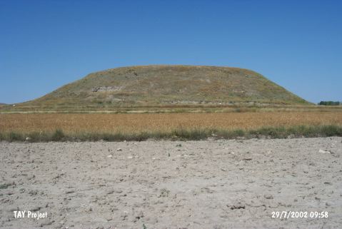 |
|
Type:
|
Mound |
|
Altitude:
|
1250 m |
|
Region:
|
Central Anatolia |
|
Province:
|
Nevsehir |
|
District:
|
Avanos |
|
Village:
|
Sarilar |
|
Investigation Method:
|
Excavation |
|
Period:
|
|
|
|
|
 |
|
| It lies approximately 4 km northwest of Sarilar Town of Avanos District; northeast of Nevsehir Province. The Sarilar-Topakli road runs 400 m east; Kirsehir-Kayseri motorway runs 11 km north of the mound. It is located on a flat plain. It measures 29-30 m in height together with the natural elevation and 300 m in diameter [Sever 1993:pic.1]. It is estimated to cover an area of five acres. It was introduced by D.H. French; and investigated by a survey team under H. Sever. Largely sherds of the Assyrian Trade Colony Period; the second millennium BC; the Iron Age (Phrygian) and the Hellenistic Period were collected from the surface. The trench opened on the eastern foot during the excavations carried out in 1991 yielded EBA pottery [Sever 1993:pic.9-10]. Although following years have shed lights on the remains of the second millennium BC; not much information has been provided about the EBA settlement. It was also investigated by S. Omura. Pottery of the EBA; the MBA-LBA; the Iron and Classical Ages was recovered. It takes place in the registered archaeological sites list prepared by Ministry of Culture and Tourism. |
| Location: |
| Geography and Environment: |
| History: |
| Research and Excavation: |
| Stratigraphy: |
| Small Finds: |
| Remains: |
| Interpretation and Dating: |