|
©The Archaeological Settlements of Turkey - TAY Project
|
|
|
|
|
|
Baladiz / Baradiz |
|
|
For site maps and drawings please click on the picture...  |
For photographs please click on the photo... 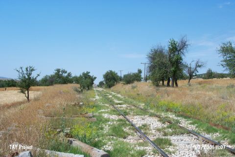 |
|
Type:
|
Habitation Site / Workshop |
|
Altitude:
|
890 m |
|
Region:
|
Mediterranean |
|
Province:
|
Isparta |
|
District:
|
Gönen |
|
Village:
|
Gümüsgün |
|
Investigation Method:
|
Excavation |
|
Period:
|
EP |
|
|
|
 |
|
| Location: This site lies between Gümüsgün (Baradiz) and Igdecik villages; southeast of Gönen District; northwest Isparta Province. It is 2.3 km away from the Gümüsgün train station. It lies on either side of a small hill that has been carved by railroad tracks. |
| Geography and Environment: The site lies on a small hill where the Gönen and the Keçiborlu plains meet. Although the diameter of the hill is reported to be approximately 80-100 m across; its height above the plains is not given. According to H. R. Cohen and Oguz Erol who conducted geomorphological studies in the area; the soft sand on the surface of this hill indicates that this hill used to be located near the earlier shores of the lake and that this elevated terrain was formed when the Burdur Lake rose. Erol further suggests that the first human activity in the area dates to the end of the last Ice Age when the level of the Burdur lake fell from 950-945 m to 935-930 m. This must have been a suitable region for hunting in the Epipalaeolithic. |
| History: |
| Research and Excavation: The first archaeological research in the area was conducted by Herbert Louis and geographer Niyazi Çitakoglu in 1937. The microliths and other chipped stone tools they collected were studied by Kurt Bittel; who dated the site to the end of the Epipalaeolithic and the beginning of the Neolithic; even though the sample of artifacts lacked characteristic qualities. A small 3x4 m trench was begun south of the railroad tracks in 1944 under the direction of Sevket Aziz Kansu. The first 70 cm beneath the surface contained the back-fill from the construction of the railroad tracks. Microlith tools and debitage products appeared between 160-185 cm below the surface. The artifacts were concentrated in the upper part of this layer. Virgin soil was reached at 185 cm. Another trench 2x3 m in size was opened in the lower terrace of the hill; parallel to the tracks. The top 70 cm of this trench was especially rich in microlith tools. Surprisingly; it also yielded a few pieces of pottery. Similar pottery mixed finds also appeared in another trench excavated between this hill and the skirts of Mount Kiran. The only other archaeological study this area encountered was a survey E.Y. Bostanci conducted on his return from his excavations in Antalya [Bostanci 1967b:57]. |
| Stratigraphy: |
| Small Finds: The microlith tools found on the small hill named after the nearby town of Baladiz have not been described in detail. We know that the tools include micro-burins; triangles; other geometric tools; and micro-cores. Bostanci believes that the tools he collected here in his survey resemble the level C 1 artifacts of his excavations in the Kumbucagi Rock Shelter. Although real microlith points or geometric microliths characteristic of the Epipalaeolithic have not been found; with the excavation and research conducted so far; for now this site is assigned to the Epipalaeolithic. |
| Remains: |
| Interpretation and Dating: |