|
©The Archaeological Settlements of Turkey - TAY Project
|
|
|
|
|
|
Arslantepe |
|
|
For site maps and drawings please click on the picture...  |
For photographs please click on the photo... 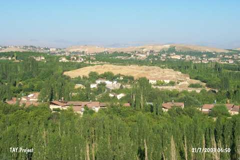 |
|
Type:
|
Mound |
|
Altitude:
|
830 m |
|
Region:
|
Eastern Anatolia |
|
Province:
|
Malatya |
|
District:
|
Merkez |
|
Village:
|
Bahçebasi |
|
Investigation Method:
|
Excavation |
|
Period:
|
Middle Iron Age Early Iron Age |
|
|
|
 |
|
| Location: It is located at Ordüzü Mevkii; northeast of the Malatya Province. At present; Ordüzü Mevkii is a part of the city. The mound Arslantepe (Lions Hill) is named after the lions at the gate which were on the surface even before the excavation started. |
| Geography and Environment: The excavations suggested that the site had been occupied between the Chalcolithic Age and the Late Hittite Period. With its dimensions; 40 m in height and 120x200 m in size; it is one of the biggest mounds of the region. It is surrounded with gardens which are very rich in water. The abundance of water resources played an important role in selecting it as a mainland throughout the ages. It is also located on the trade route running to Central Anatolia from North Mesopotamia via Tohma Valley. |
| History: |
| Research and Excavation: The first excavations were initiated by L. Delaporte between 1932-39. Following these initial excavations which focused on the Hittite remains, a second campaign was started to determine the whole layering of the mound under the direction of C. Schaeffer in 1947-48. The excavations initiated by P. Meriggi in 1961 to reveal epigraphic finds were transferred to S. Puglisi in 1963 as no promising finds were obtained. Upon decease of A. Palmieri, the excavations were undertaken by M. Frangipane on behalf of the Univesity of La Sapienza. The excavations still continue neary for 38 years. It takes place in the registered archaeological sites list prepared by Ministry of Culture and Tourism. |
| Stratigraphy: The Arslantepe Mound yielded ruins from the Islamic, Byzantine and Roman Periods. As a result of the excavations conducted in three different sections including the northeastern, southwestern and western sections since 1932, the following layers were determined: Late Hittite (1200-900 BC) Hittite Empire (1600-1.200 BC) MBA (Arslantepe V A) EBA III A-C (Arslantepe VI D1-3) EBA II (Arslantepe VI C) EBA IB (Arslantepe VI B1 and B2) EBA IA / Local Late Uruk (Arslantepe VI A) Late Chalcolithic / Local (Arslantepe VII) Late Obeid / Transition (Arslantepe VIII). |
| Small Finds: Architecture: History of Arslantepe probably started with an agricultural village who settled down in the fertile and well-irrigated Malatya basin during the 6th or 7th millennium BC. Presence of a people with a social hierarchy was identified even during the first half of the 4th millennium BC. As a very large settlement, it expands around a monumental center to the west of the mound on which now rises a 1 m thick large building erected with unbaked bricks. The exposed section of the building include a relatively large hall with heavily destructed walls bearing red and black decorations, and four reused bays divided by columns of unbaked earth coated with a white mortar. However, it is believed that it was originally arranged as a reception hall. Lesser amount of archiectural elements, and absence of any interior elements such as altar and niches strenghten the idea that it was not used for worshipping. The two temples at Arslantepe are almost similar in plan and dimensions, bearing characteristic features. They consist of large halls decorated with niches, and arranged for worshipping with an altar at the end of the room and two central pedions in front of the hearth. There is a low platform on the long side across two windows, which provide communication between the two lateral rooms in the temple "b" within the palatial complex. It appears that these two windows were most probably closed as evidenced by the timber frame remains and trace of snib on the wall, being the only opening used for direct communication with public. It was found that the entrance was from the longer side of the building, with a passage from a room placed laterally to the cell. Presence of wall decorations in the side room suggests that this section was inhabited by belief groups. Pottery: The excavations at the Arslantepe settlement revealed that the second building level is dated to the Iron Age. Sherds specific to the Iron Age are observed on this building level. The colors of the pottery in this period are beige and yellowish. Illicit diggings resulted in destruction of the architectural remains at Arslantepe. Statue/Relief: French archeaologist Delaporte yielded the "Lion Gate" orthostats and gate lion of Malatya-Arslantepe during the excavations. These lions are dated to the "Late Hittite Art I" period by E. Akurgal. Among the Arslantepe orthostats, the relief of "Storm-God in Chariot" represents the highest level of its style with its size and elaborate craftsmanship and distinctive theme. The human figurines in the Malatya reliefs represent characteristic features of the "Late Hittite Art I". There are four reliefs which constitute the Malatya group belonging to the "Late Hittite Art II". Specimens of this phase include two calcerous orthostats, which were found outside the Arslantepe mound, decorated with depictions of chariot and hunting scenes. Also included are the reliefs of "Lion and Deer Hunt from Chariot", fragment of an orthostat bearing "Ritual Meals" and two stelea. Of these hunting scenes, the relief of "Lion Hunt" has been preserved at the Ankara Museum of Anatolian Civilizations while the "Deer Hunt" at the Museum of Louvre in Paris. |
| Remains: |
| Interpretation and Dating: Arslantepe houses a settlement from the First Bronze Age lasting until the Iron Age. It is represented by Late Hittite settlement during the Iron Age. It is particularly significant in tracing and defining the phases of Late Hittite Art. Although it has been destructed due to illicit diggings, it represents one of the longest excavations conducted in Anatolia so far. |