|
©The Archaeological Settlements of Turkey - TAY Project
|
|
|
|
|
|
Asarkaya |
|
|
For site maps and drawings please click on the picture...  |
For photographs please click on the photo... 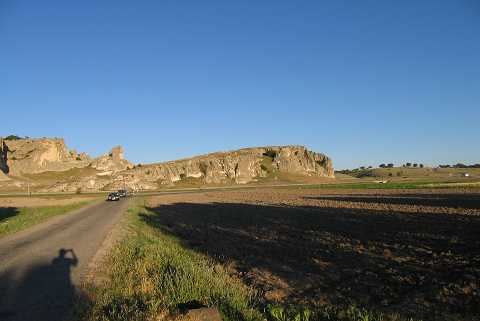 |
|
Type:
|
Flat Settlement |
|
Altitude:
|
965 m |
|
Region:
|
Aegean |
|
Province:
|
Kütahya |
|
District:
|
Merkez |
|
Village:
|
Sabuncu |
|
Investigation Method:
|
Survey |
|
Period:
|
Early Phrygian Middle Phrygian Late Phrygian |
|
|
|
 |
|
| Two kilometers south of Sabuncupinar lie some rock-cut houses at so called Asarkaya. There are prehistoric settlements on the flat ground between the rock and the railway running nearby at where the rocks make a slow inclination downward. A vast majority of the sherds collected from the surface during the "Surveys in the Provinces of Kütahya, Bilecik and Eskisehir" conducted by T. Efe in 1989 are dated to the Late Chalcolithic Age. Furthermore, in addition to flint tools which may have been from the Upper Palaeolithic or Mesolithic Periods, restricted amount of Phrygian material was recovered. It takes place in the registered archaeological sites list prepared by Ministry of Culture and Tourism. |
| Location: This site lies northeast of the city of Kütahya; 2 km south of the town of Sabuncular; in the area known as Asarkaya. |
| Geography and Environment: The geographical information provided by the researcher indicates that Asarkaya is a rock outcrop which lies on the northwestern skirts of Mount Türkmen. The finds were found on a slope of the rock outcrop and on the flat area beside it. The region is abundant in natural caves; which must have been attractive shelters for the first producers. |
| History: |
| Research and Excavation: |
| Stratigraphy: |
| Small Finds: |
| Remains: |
| Interpretation and Dating: |