|
©The Archaeological Settlements of Turkey - TAY Project
|
|
|
|
|
|
Düden |
|
|
For site maps and drawings please click on the picture...  |
For photographs please click on the photo... 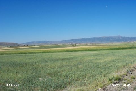 |
|
Type:
|
Mound |
|
Altitude:
|
1100 m |
|
Region:
|
Mediterranean |
|
Province:
|
Burdur |
|
District:
|
Yesilova |
|
Village:
|
Karaatli |
|
Investigation Method:
|
Survey |
|
Period:
|
Early |
|
|
|
 |
|
| The mound named by M. Özsait in 1982 Survey; lies southwest of Burdur; northeast of Yesilova; 4.3 km northeast of Karaatli village. Glossy red slipped; burnished ceramics dating back to the LNA-ECA were found on the surface. Özsait claims that he had not came upon another later settlement other than Early Chalcolithic Age. |
| Location: This site lies southwest of the city of Burdur; northeast of the town of Yesilova; approximately 4.3 km northeast of the village of Karaatli in the district of Düden. It lies immediately south of the road which runs between Karaatli and Burdur and lies north of the village of Yarisli [Özsait 1991b:table XIX/9]. |
| Geography and Environment: Çatalöz Stream flows 300 m north of the site; which lies on a small plain between the Salda and Yarasli Lakes. This stream probably flowed closer to the mound. There was a swamp known as the Karagöz Swamp south of the mound when the site was surveyed. It has been reported that the mound is very low; almost the same level as the plain it lies on; and that it is used for agriculture. It is; therefore; difficult to locate. The dimensions of the mound have not been given. The name Düden was given by Özsait. |
| History: |
| Research and Excavation: |
| Stratigraphy: |
| Small Finds: |
| Remains: |
| Interpretation and Dating: |