|
©The Archaeological Settlements of Turkey - TAY Project
|
|
|
|
|
|
Dündartepe |
|
|
For site maps and drawings please click on the picture...  |
For photographs please click on the photo... 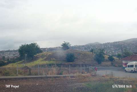 |
|
Type:
|
Mound |
|
Altitude:
|
80 m |
|
Region:
|
Black Sea |
|
Province:
|
Samsun |
|
District:
|
Merkez |
|
Village:
|
Merkez |
|
Investigation Method:
|
Excavation |
|
Period:
|
|
|
|
|
 |
|
| Location: The site lies approximately 3 km southeast of Samsun; almost inside the modern city; on the slope sloping down to Merd River. |
| Geography and Environment: The 220x200 m mound was split into two by Samsun-Sivas Railway. The northern and northwestern slopes of the 15 m high mound are steep. Surrounded by gardens; the site is located in a watery area. The northern and northeastern edges of the railway fissure are high. The mound is also known as "Öksürüktepe" (Öksürükdede); because it is believed that the saint on the hill offers healing to the sick children. |
| History: |
| Research and Excavation: It was excavated in 1940-41 by a team under K. Kökten; N. Özgüç and T. Özgüç. The excavation was carried out in the flat area due to the damage caused during the railway construction; on the slope facing the road and top hill. The excavation team was mainly concerned with figuring out the relationship between the prehistoric cultures of the Black Sea and the Central Anatolia and Marmara regions. It takes place in the registered archaeological sites list prepared by Ministry of Culture and Tourism. |
| Stratigraphy: Three levels were revealed at the end of this excavation: Level 1: Eneolithic / Chalcolithic Age Level 2: Copper / Early Bronze Age Level 3: Hittite Period / MBA-LBA. Four building levels were uncovered in Level 1; which is reported to be 4.5 m thick. |
| Small Finds: Architecture: Although the existence of the buildings with plastered walls; at which; wood and stone was used together; in Building levels II and III was observed; it was not possible to acquire a plan because of the smallness of the excavated area. A room with a clay plastered pebble floor; was revealed. Although Özgüç claims that the building technique resembles that of Central Anatolia; the existence of wattle and daub buildings may be interpretated because of the abundance of thick plaster pieces and burnt wood pieces; which is different from the building technique (significantly of mud-brick) of Central Anatolia. Pottery: Hand-made sherds; resembling each other; were collected from all levels. They are of black; gray; and brown faced; sand-tempered ware. Red vessels are coarser. Knobbed handles are existent. Sherds decorated with irregular lines are rare. Some of them are decorated with white incrustation. Nail impressions are also existent on some sherds. Chipped Stone: Obsidian blade knives were recovered. Ground Stone: Grinding stone and burnishing stones were found. There is no detailed information about the small finds. Bone / Antler: A stab made of deer antler is one of the interesting finds. |
| Remains: |
| Interpretation and Dating: The lowest level ( Level 1) of Dündartepe was not able to provide much information because of the smallness of the excavated area. It resembles the Chalcolithic Age of Alisar; Alacahöyük; and Pazarli due to the affinities of pottery. However; the lack of fruit-stands; observed in Alisar and Alacahöyük; indicates some cultural differences between the site and these settlements [Kökten et al. 1945:369]. The existence of mussel shells all around the site suggests that the sea products were important for the farmers of Dündartepe. The finds of Dündartepe excavation were again researched by L. Thissen in 1990. The finds; found on the hill; were dated to the Copper Age (EBA II) by K. Kökten; N. Özgüç; and T. Özgüç. According to Thissen; these finds belong to the Late Chalcolithic Age [Thissen 1993a:212]. |