|
©The Archaeological Settlements of Turkey - TAY Project
|
|
|
|
|
|
Kilise Tepe / Maltepe |
|
|
For site maps and drawings please click on the picture...  |
For photographs please click on the photo... 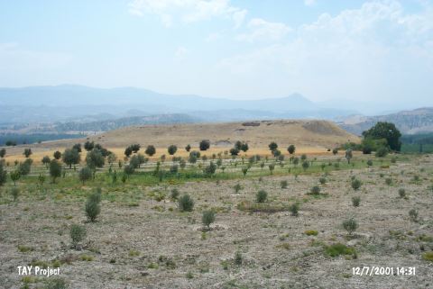 |
|
Type:
|
Mound |
|
Altitude:
|
300 m |
|
Region:
|
Mediterranean |
|
Province:
|
Mersin |
|
District:
|
Mut |
|
Village:
|
Kislaköy |
|
Investigation Method:
|
Excavation |
|
Period:
|
|
|
|
|
 |
|
| It is situated 1.350 m south of the Kisla Village, 36 km northwest of Silifke, west of Mersin; 19 km south-southeast of Mut; and 1 km north of Kislaköy. To the far north runs the Silifke-Mut motorway. It is easily accessible. It was introduced by J. Mellaart [Mellaart 1954:192] as Maltepe with surface finds belonging to the Iron Age, 2nd Millennium BC and 3rd Millennium BC settlements, followed by a surface collection in 1965 by D.H. French, who referred to the site as Kilise Tepe. It appears that the site had been occupied in temporal order from recent to earlier during the Byzantine Period, Late Roman Period, Iron Age, Late, Middle and Early Bronze Age. A stone flooring is encountered during the drills carried out in 2009 by Jackson-Postgate. This flooring and the walls in the layers above are inside a pressurized series of layers made of ash or pebble embankment between clean horizontal clay surfaces. There layers are numbered between Phase 7 and 14 following Surface 1 to 6. Bones of a new born or foetus is unearthed in the drill opened in K14a. Many different plant remains are captured from the holes between 7 and 14 including barley, wheat, grape, olive, pulses, and possibly tare. The latest Iron Age Settlement under the walls of Byzantium and Hellenistic Period is represented by Layer 1 with its fire structures, two deep round storage holes, and a very large rectangular storage area in the South. Under the above, three of four consecutive settlement surfaces exist on an open space which is sometimes crossed with smaller storage holes. The pottery associated with Layer 1 and especially White Painted IV pottery date this layer as 750 Ğ 650 BC. Bicrome and Black-on-Red type East Mediterranean wares and wares including White-Painted pottery aged in the earlier centuries are associated with Layers 2 and 3 [Jackson-Postgate 2011.426-429]. |
| Location: It lies 1 km south of the Kisla Village; about 36 km northwest of Silifke District; some 20.5 km southeast of Mut District; southwest of the Mersin Province. To the north runs the Silifke-Mut motorway. It is easy to access. |
| Geography and Environment: The mound which will be submerged together with Çingene Tepe nearby under the reservoir waters of the Kayraktepe Dam built 10 km away from Silifke on the Göksu River is also known as Maltepe (Mut). There is another settlement called Maltepe located south of Çingene Tepe on the opposite western bank of the river. It is locally known as Kilise Tepe and it was illustrated under this name in a 1:25.000 maps. It stands on a conglomeratic elevation with steep slopes and flat uphill overlooking the valley formed by the Göksu River. On the northern foot of this rocky block; there is a fresh water spring. Settlement is suggested to house a cultural deposit of ca. 20 m thick. A stream called Kurtsuyu passing by the western side joins the Göksu River down in the valley. |
| History: |
| Research and Excavation: |
| Stratigraphy: |
| Small Finds: |
| Remains: |
| Interpretation and Dating: |