| ©The Archaeological Settlements of Turkey - TAY Project | ||||||
|
|
||||||
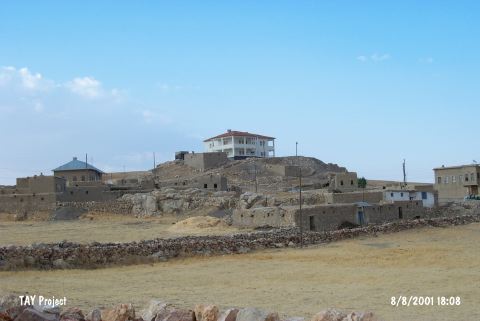
Aktil Köy |
||||||
|
|
||||||
| Ages | Maps | Photos | ||||
| Chalcolithic |
 |
 |
||||
|
|
||||||
|
Type:
|
Mound | |||||
|
Altitude:
|
1730 m | |||||
|
Diameter:
|
m- Direction: | |||||
|
|
||||||
|
Region:
|
Eastern Anatolia | |||||
|
Province:
|
Kahramanmaras | |||||
|
District:
|
Elbistan | |||||
|
Village:
|
Yalintas | |||||
|
|
||||||
|
Destruction :
|
Contemporary Settlements - Attention | |||||
|
|
||||||
|
TAYEx:
|
Visited - 8/8/2001 | |||||
|
|
||||||
|
Registration State:
|
Registered For detailed registration information please refer to Turkish pages. | |||||
 |
||||||
| Location: |
| Geography and Environment: |
| Destruction Details: The mound has been seriously damaged due to contemporary settlement. There is a two layered new house on top and old mudbrick houses locate on the slopes and skirts [TAYEx 8.8.2001]. |