| ©The Archaeological Settlements of Turkey - TAY Project | ||||||
|
|
||||||
Gürcütepe |
||||||
|
|
||||||
| Ages | Maps | Photos | ||||
| Neolithic |
 |
 |
||||
|
|
||||||
|
Type:
|
Mound | |||||
|
Altitude:
|
530 m | |||||
|
Diameter:
|
m- Direction: | |||||
|
|
||||||
|
Region:
|
Southeastern Anatolia | |||||
|
Province:
|
Sanliurfa | |||||
|
District:
|
Merkez | |||||
|
Village:
|
Gürcütepe | |||||
|
|
||||||
|
Destruction :
|
Contemporary Settlements | |||||
|
|
||||||
|
TAYEx:
|
Visited - 30/8/2001 | |||||
|
|
||||||
|
Registration State:
|
For detailed registration information please refer to Turkish pages. | |||||
 |
||||||
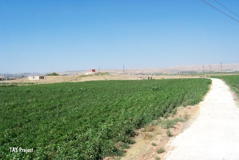
| Location: This site lies 4 km southeast of the city of Sanliurfa; near the village of Gürcütepe. It is possible to get to the site via the road from the city center to the village of Gürcütepe. |
| Geography and Environment: The four adjacent mounds known as Gürcütepe lie in the northern part of the Harran Plain. The excavators have labeled these four low-lying mounds (not represented on a 1:100;000 map) as Gürcütepe I; Gürcütepe II; III and IV. The mounds are aligned along Sirrin Stream which originates from a spring in the Sanliurfa city center. The mound of Gürcütepe II is 8 meters high and has a 200 m diameter. The dimensions of the other mounds have not been provided. |
| Destruction Details: The mound is destructed by the water reservoir on top; the buildings on south slope and the canal on north side [TAYEx 30.8.2001]. |