| ©The Archaeological Settlements of Turkey - TAY Project | ||||||
|
|
||||||
Hashöyük |
||||||
|
|
||||||
| Ages | Maps | Photos | ||||
| Chalcolithic EBA IA |
 |
 |
||||
|
|
||||||
|
Type:
|
Mound | |||||
|
Altitude:
|
1230 m | |||||
|
Diameter:
|
210 m- Direction: NE-SW | |||||
|
|
||||||
|
Region:
|
Central Anatolia | |||||
|
Province:
|
Kirsehir | |||||
|
District:
|
Merkez | |||||
|
Village:
|
Hashöyük | |||||
|
|
||||||
|
Destruction :
|
Illicit Digging - Contemporary Settlements | |||||
|
|
||||||
|
TAYEx:
|
Visited - 30/7/2002 | |||||
|
|
||||||
|
Registration State:
|
Registered For detailed registration information please refer to Turkish pages. | |||||
 |
||||||
| Location: It is near the village it was named after; 35 km east of the Kirsehir Province. |
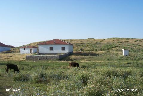
| Geography and Environment: It is reported to measure 8-10 m in height and 400x300 m in dimensions as an oval hill. It has not been damaged much. |
| Destruction Details: There houses on skirts and slopes of the mound. Two pits of illicit diggings seen on southern slope [TAYEx 30.7.2002]. |