| ©The Archaeological Settlements of Turkey - TAY Project | ||||||
|
|
||||||
Helvaci Höyücek |
||||||
|
|
||||||
| Ages | Maps | Photos | ||||
| EBA |
 |
 |
||||
|
|
||||||
|
Type:
|
Mound | |||||
|
Altitude:
|
40 m | |||||
|
Diameter:
|
m- Direction: | |||||
|
|
||||||
|
Region:
|
Aegean | |||||
|
Province:
|
Izmir | |||||
|
District:
|
Aliaga | |||||
|
Village:
|
Helvaci | |||||
|
|
||||||
|
Destruction :
|
Illicit Digging - Highways, roads, bridges etc. - Attention | |||||
|
|
||||||
|
TAYEx:
|
Visited - 17/9/2000 | |||||
|
|
||||||
|
Registration State:
|
For detailed registration information please refer to Turkish pages. | |||||
 |
||||||
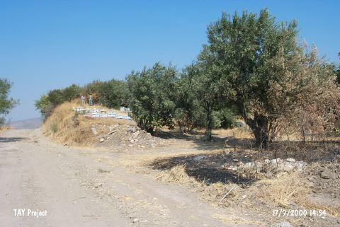
| Location: It is located on the northern side of the Larisa-Eski Foça road on the west of the Aliaga-Menemen motorway; 4 km west-southwest of Helvaci Village; north-northwest of Menemen District; northwest of Izmir Province. It is locally known as Höyücek; and it was renamed as Helvaci Höyücek in order to prevent any confusion with other mounds. It is cited as Helvaci in some publications [Yakar 1985:152]; while only as Höyücek in some others [Korfmann et al. 1994:104]. The area is locally known as Üyücek. |
| Geography and Environment: It is a small hill between the vineyards and olive trees on the western part of the Asagi Gediz Plain. It is suggested that the site was near the Gediz River; even on the sea shore during the era of the settlement. Now; it is 18 km far from the sea. Traces of illicitly dug pits are observed on the surface. It has been partly damaged during the construction of the road. |
| Destruction Details: The mound has been severely damaged due to illicit diggings. These pits have revealed the architectural remains of the settlement. Its western section was cut by a road [TAYEx 17.9.2000]. |