| ©The Archaeological Settlements of Turkey - TAY Project | ||||||
|
|
||||||
Inbogazi Magaralari |
||||||
|
|
||||||
| Ages | Maps | Photos | ||||
| Chalcolithic EBA |
 |
 |
||||
|
|
||||||
|
Type:
|
Cave | |||||
|
Altitude:
|
120 m | |||||
|
Diameter:
|
m- Direction: | |||||
|
|
||||||
|
Region:
|
Marmara | |||||
|
Province:
|
Balikesir | |||||
|
District:
|
Havran | |||||
|
Village:
|
Inönü | |||||
|
|
||||||
|
Destruction :
|
Contemporary Settlements - Attention | |||||
|
|
||||||
|
TAYEx:
|
Visited - 25/6/2000 | |||||
|
|
||||||
|
Registration State:
|
For detailed registration information please refer to Turkish pages. | |||||
 |
||||||
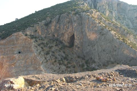
| Location: It is located 1500 m behind the village of Inönü; 6 km east of the Havran District; west of the Balikesir Province. |
| Geography and Environment: In the vicinity of Inbogazi Mevkii; aside Karanlik Magara; there are several caves like Devedami; Aydinlik and Andik. Introduced as Inbogazi Caves; those caves stand on the calcareous slope of the Büyük Çal mountain facing the Gelinderesi stream. Among them; only Karanlik Magara was investigated and provided information about the local culture. Therefore; the finds should have been presented under the name of the Karanlik Magara. The construction of the Havran Dam is in progress. The caves will be partly influenced by the dam. |
| Destruction Details: The cave is in the construction area of the Havran Dam. It is expected to be partially flooded when the construction of the dam is over [TAYEx 25.6.2000]. |