| ©The Archaeological Settlements of Turkey - TAY Project | ||||||
|
|
||||||
Kayapinar |
||||||
|
|
||||||
| Ages | Maps | Photos | ||||
| EBA IA |
 |
 |
||||
|
|
||||||
|
Type:
|
Mound | |||||
|
Altitude:
|
1320 m | |||||
|
Diameter:
|
m- Direction: | |||||
|
|
||||||
|
Region:
|
Black Sea | |||||
|
Province:
|
Tokat | |||||
|
District:
|
Artova | |||||
|
Village:
|
Yenice | |||||
|
|
||||||
|
Destruction :
|
Illicit Digging - Attention | |||||
|
|
||||||
|
TAYEx:
|
Visited - 10/8/2003 | |||||
|
|
||||||
|
Registration State:
|
Registered For detailed registration information please refer to Turkish pages. | |||||
 |
||||||
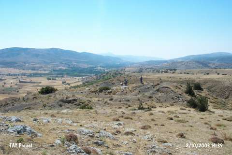
| Location: It lies 5 km west of the Yenice Village; 17 km north of Artova; some 25 km southwest of the Tokat Province. It is located 3 km north of the railway running from Artova to Ulus. |
| Geography and Environment: It is a small oval mound; 45 m wide and 70 m long; with a cultural deposit of 2.5 m thick. It is 60 m higher than the stream under passing. To the 70 m north; lies a spring and Kurtini Cave on a rocky block over this spring. It is informed that the interior of the cave; not surveyed yet; is full of earth. The mound is located on the ridge of a stream originating from the Akdag range and reaching to the Bebek Stream. The underlying valley has a very fertile land. The mound has been almost demolished by the treasure hunters. |
| Destruction Details: The mound has been destructed by illicit diggings [TAYEx 10.8.2003]. |