| ©The Archaeological Settlements of Turkey - TAY Project | ||||||
|
|
||||||
Kaynarca Mevkii |
||||||
|
|
||||||
| Ages | Maps | Photos | ||||
| Neolithic |
 |
 |
||||
|
|
||||||
|
Type:
|
Mound | |||||
|
Altitude:
|
20 m | |||||
|
Diameter:
|
m- Direction: | |||||
|
|
||||||
|
Region:
|
Marmara | |||||
|
Province:
|
Çanakkale | |||||
|
District:
|
Gelibolu | |||||
|
Village:
|
Sütlüce | |||||
|
|
||||||
|
Destruction :
|
Agriculture | |||||
|
|
||||||
|
TAYEx:
|
Visited - 20/6/2000 | |||||
|
|
||||||
|
Registration State:
|
Registered For detailed registration information please refer to Turkish pages. | |||||
 |
||||||
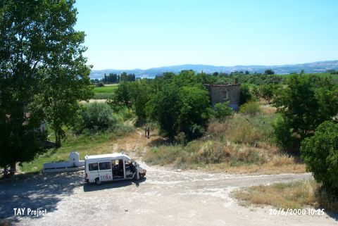
| Location: It is a small mound located to the northeast of the city of Çanakkale; 8 km southwest of the town of Gelibolu; 400 m south of the highway and 50 m south of the Kaynarca water fountain. The survey code of this site is G 3 / 1. |
| Geography and Environment: The site lies on a low terrace created by Münipbey (Ümitbey) Stream. Here in a 50x50 m area both later ceramics and prehistoric material cultural finds were found. Although the site is now 2 km from the stream; in prehistory the settlement must have been next to the stream and later filled with up with alluvial deposits. |
| Destruction Details: The settlement is seriously damaged due to intense agriculture. Southern; western; and eastern parts of the mound are being used as fields; and it is cut by a secondary road that passes over. The northern skirts are cut and the materials of the municipality's asphalt facilities are piled in this area [TAYEx 20.6.2000]. |