| ©The Archaeological Settlements of Turkey - TAY Project | ||||||
|
|
||||||
Altintepe |
||||||
|
|
||||||
| Ages | Maps | Photos | ||||
| EBA IA |
 |
 |
||||
|
|
||||||
|
Type:
|
Mound | |||||
|
Altitude:
|
1290 m | |||||
|
Diameter:
|
m- Direction: | |||||
|
|
||||||
|
Region:
|
Eastern Anatolia | |||||
|
Province:
|
Erzincan | |||||
|
District:
|
Üzümlü | |||||
|
Village:
|
Merkez | |||||
|
|
||||||
|
Destruction :
|
Illicit Digging | |||||
|
|
||||||
|
TAYEx:
|
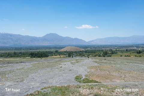
Visited - 24/6/2003 | |||||
|
|
||||||
|
Registration State:
|
Registered For detailed registration information please refer to Turkish pages. | |||||
 |
||||||
| Location: It lies to the immediate north of the Erzurum-Erzincan motorway, 20 km east of Erzincan. |
| Geography and Environment: Lying on the northern edge of the very fertile Erzincan Plain, Altintepe also commands the renown trade road running from East Anatolia to Central Anatolia. The oval-planned hill on which the fortress of Altintepe rises is 60 m high above the plain. It is 1290 m high. |
| Destruction Details: The mound; which has previously been excavated; is being damaged due to illicit diggings and cultivation [TAYEx 24.6.2003]. Four steleae, 4 stele pedestals and 1 altar identified out in the open air sanctuary in 1959 by T. Özgüç were destroyed and were found in fragments during 2008 excavations [Karaosmanoğlu 2010:23]. |