| ©The Archaeological Settlements of Turkey - TAY Project | ||||||
|
|
||||||
Küllünün Ini |
||||||
|
|
||||||
| Ages | Maps | Photos | ||||
| Palaeolithic/Epipalaeolithic EBA |
 |
 |
||||
|
|
||||||
|
Type:
|
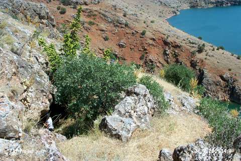
Rock Shelter | |||||
|
Altitude:
|
880 m | |||||
|
Diameter:
|
m- Direction: | |||||
|
|
||||||
|
Region:
|
Eastern Anatolia | |||||
|
Province:
|
Elazig | |||||
|
District:
|
Agin | |||||
|
Village:
|
Yeniyapan | |||||
|
|
||||||
|
|
||||||
|
|
||||||
|
TAYEx:
|
Visited - 16/7/2003 | |||||
|
|
||||||
|
Registration State:
|
For detailed registration information please refer to Turkish pages. | |||||
 |
||||||
| Location: The cave site is northwest of the city of Elazig; 5 km west of the town of Agin; close to the village of Yenipayam which used to be called Hastek; in the neighborhood of Gedikler along the Arapkir Stream. |
| Geography and Environment: It is located on a slope near dam reservoir and its moth faces south. The name of the rock shelter is probably local. |
| Destruction Details: |