| ©The Archaeological Settlements of Turkey - TAY Project | ||||||
|
|
||||||
Musular |
||||||
|
|
||||||
| Ages | Maps | Photos | ||||
| Neolithic 14C |
 |
 |
||||
|
|
||||||
|
Type:
|
Flat Settlement | |||||
|
Altitude:
|
1145 m | |||||
|
Diameter:
|
m- Direction: | |||||
|
|
||||||
|
Region:
|
Central Anatolia | |||||
|
Province:
|
Aksaray | |||||
|
District:
|
Gülagaç | |||||
|
Village:
|
Kizilkaya | |||||
|
|
||||||
|
|
||||||
|
|
||||||
|
TAYEx:
|
Visited - 3/8/2002 | |||||
|
|
||||||
|
Registration State:
|
Registered For detailed registration information please refer to Turkish pages. | |||||
 |
||||||
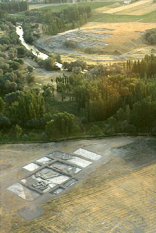
| Location: This site of Musular lies in the province of Aksaray; 1 km south of the village of Kizilkaya; district of the Gülagaç Municipality. About 18 km after the Aksaray-Nevsehir road turns south from the Güzelyurt-Ihlara turning; there is a road to Gülagaç district and Demirci Beldesi. The site can be reached by following the road to right; about 500 m after this turning. Musular Mevkii lies to the west of Melendiz River and it is about 300-400 m far from Asikli Höyük. Code P 33/8. |
| Geography and Environment: Musular lies in a volcanic area north of Mount Hasan and the Melendiz Mountains; in the fertile Ihlara Valley; on the western shore of Melendiz Stream. It is located immediately west of the Aceramic Neolithic site of Asikli. Agricultural activities are still being carried out in an area outside the excavation area but which actually is included in the settlement. The open-air site lies on a rock outcrop and extends over a 220x120 m area. The highest point of the site is at an attitude of 1120 m above the sea level [Özbasaran 1999:149]. It lies on the tuff formatted bedrock and the bedrock can be seen on the surface in some areas. |
| Destruction Details: |