| ©The Archaeological Settlements of Turkey - TAY Project | ||||||
|
|
||||||
Pandir Bahçe / Üveyiktepe |
||||||
|
|
||||||
| Ages | Maps | Photos | ||||
| EBA |
 |
 |
||||
|
|
||||||
|
Type:
|
Mound | |||||
|
Altitude:
|
45 m | |||||
|
Diameter:
|
m- Direction: | |||||
|
|
||||||
|
Region:
|
Marmara | |||||
|
Province:
|
Edirne | |||||
|
District:
|
Enez | |||||
|
Village:
|
Küçük Evren | |||||
|
|
||||||
|
Destruction :
|
Agriculture | |||||
|
|
||||||
|
TAYEx:
|
Visited - 16/6/2000 | |||||
|
|
||||||
|
Registration State:
|
For detailed registration information please refer to Turkish pages. | |||||
 |
||||||
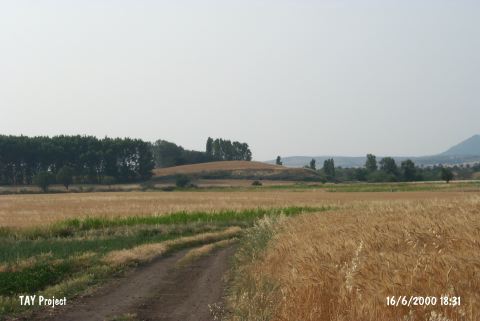
| Location: It lies northwest of the Küçük Evren Village; southeast of the Enez District; south-southwest of the Edirne Province. It is 300 m far from the village road connecting the village to the motorway (Enez-Kesan motorway). It is locally known as Üveyiktepe. |
| Geography and Environment: It is located on an alluvial elevation to the northwest and north of the Küçük Evren Village. It measures 8 m in height and 140x80 m in dimensions. It has an oval shape. The Incirli Stream flowing through the south; first passing to the north and then to the east has formed steeper slopes on these sections by truncation. The fresh water spring on the eastern foothill; probably; met the water requirements of the inhabitants. It is reported that the surface of the mound has been destroyed due to heavy cultivation [Basaran 1999:171]. |
| Destruction Details: The surface of the settlement is being used as a wheat field [TAYEx 16.6.2000]. |