| ©The Archaeological Settlements of Turkey - TAY Project | ||||||
|
|
||||||
S 63/26 |
||||||
|
|
||||||
| Ages | Maps | Photos | ||||
| Neolithic |
 |
 |
||||
|
|
||||||
|
Type:
|
Flat Settlement | |||||
|
Altitude:
|
870 m | |||||
|
Diameter:
|
m- Direction: | |||||
|
|
||||||
|
Region:
|
Southeastern Anatolia | |||||
|
Province:
|
Siirt | |||||
|
District:
|
Kurtalan | |||||
|
Village:
|
Merkez | |||||
|
|
||||||
|
Destruction :
|
Contemporary Settlements | |||||
|
|
||||||
|
TAYEx:
|
Visited - 6/7/2003 | |||||
|
|
||||||
|
Registration State:
|
For detailed registration information please refer to Turkish pages. | |||||
 |
||||||
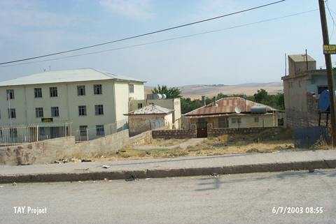
| Location: This site lies west of the city of Siirt; approximately 1.5 km southwest of the town of Kurtalan; northeast of the Güney Mahalle elementary school at the and of Çobanoglu street. The exact location of the mound is opposite to the General Directorate of Education of Kurtalan; 700 m away from the clock tower. There are buildings on this area today. |
| Geography and Environment: This open air site lies in an agricultural field southeast of the village of Güney Mahalle. Obsidian and flint tools were collected in a 300x50 m area. When this research was conducted at the site; the field was cultivated. The spring northeast of the site must have been the main water supply for the inhabitants of this site. Only 10 pieces of pottery dating to "late-periods" were found. A total of 2;534 chipped stone artifacts were found. The method of collection of artifacts and the artifact densities are not mentioned. The exact location of the site has not been described. Since another mound-site by the village was called Güney Höyük after the village; this site was given a code-name. |
| Destruction Details: The find spot has vanished under the modern settlement [TAYEx 6.7.2003]. |