| ©The Archaeological Settlements of Turkey - TAY Project | ||||||
|
|
||||||
Bademagaci |
||||||
|
|
||||||
| Ages | Maps | Photos | ||||
| Neolithic EBA 14C |
 |
 |
||||
|
|
||||||
|
Type:
|
Mound | |||||
|
Altitude:
|
780 m | |||||
|
Diameter:
|
m- Direction: | |||||
|
|
||||||
|
Region:
|
Mediterranean | |||||
|
Province:
|
Antalya | |||||
|
District:
|
Merkez | |||||
|
Village:
|
Bademagaci | |||||
|
|
||||||
|
Destruction :
|
Agriculture - Attention | |||||
|
|
||||||
|
TAYEx:
|
Visited - 24/6/2001 | |||||
|
|
||||||
|
Registration State:
|
Registered For detailed registration information please refer to Turkish pages. | |||||
 |
||||||
| Location: This site is in the Antalya province; about 2 km north of the village of Bademagaci. It is 50 km from the Antalya city center and 20 km from the Bucak Municipality [Duru 1995a:69] and it is located on the eastern side of the Antalya-Isparta road. |
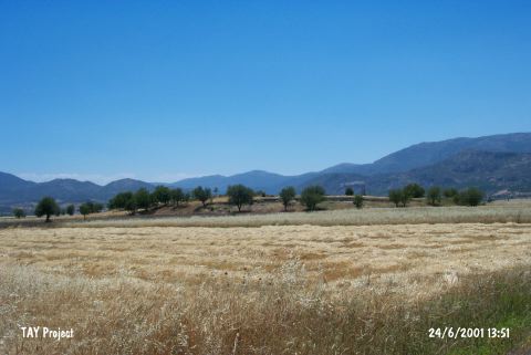
| Geography and Environment: This mound; which used to be known as Kizilkaya; lies at the southern border of "Göller Bölgesi" (the Lakes Region) and 5 km north of the Çubuk Beli natural gorge between the Taurus Mountains and the flat Antalya Plain where the modern highway has been built [Duru 1995a: 69; 1996b: 49]. The site; surrounded by mountains on all sides; lies in a low plain. The mound is 9 m above the level of the plain and has a 210 m diameter north-south and 120 m diameter east-west. It is believed that virgin soil is 2-3 m beneath the level of the plain [Duru 1995a: 69-70;73]. The excavations are being carried out on the eastern section and the cultivated area on the west reaches this excavated part of the mound. The mound was measured 200x100 m horizontally and 7m high from the sea level in 2010 [Umurtak 2011:35]. |
| Destruction Details: The western part of the mound is being cultivated spite of archaeological excavations [TAYEx 24.6.2001]. |