| ©The Archaeological Settlements of Turkey - TAY Project | ||||||
|
|
||||||
Üçagizli Magarasi |
||||||
|
|
||||||
| Ages | Maps | Photos | ||||
| Palaeolithic/Epipalaeolithic 14C |
 |
 |
||||
|
|
||||||
|
Type:
|
Cave | |||||
|
Altitude:
|
20 m | |||||
|
Diameter:
|
m- Direction: | |||||
|
|
||||||
|
Region:
|
Mediterranean | |||||
|
Province:
|
Hatay | |||||
|
District:
|
Yayladagi | |||||
|
Village:
|
Meydan | |||||
|
|
||||||
|
|
||||||
|
|
||||||
|
TAYEx:
|
Visited - 23/7/2001 | |||||
|
|
||||||
|
Registration State:
|
For detailed registration information please refer to Turkish pages. | |||||
 |
||||||
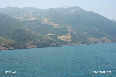
| Location: The cave is located at Yayladagi district, 1 km south of Meydan Quarter, east-southeast of Senköy Quarter, south of Samandag district, southwest of Hatay (Merkez). The cave is at approximately 10 km south of Asi River, at the foothills of Al Ansariye Mountain, at the northeastern slope of Kel Mountains. |
| Geography and Environment: The cave is a natural cavity carved into crustaceous limestone. It is 18 m above sea-level. The mouth of this cavity faces southwest and it consists of three sections in northeast; southwest and southeast directions. The cave interior is comprised of a 200 square meter living area. Its height has a variation between 4.5-5 m and 2.5 m. The anthrophogenic sediment on the cave walls is approximately 2 m thick. There are fresh water springs nearby. As can be seen on a 1:100.000 scaled map; especially the Meydan Köy region is rich in caves and rock-shelters. |
| Destruction Details: |