| ©The Archaeological Settlements of Turkey - TAY Project | ||||||
|
|
||||||
Barcin Höyük |
||||||
|
|
||||||
| Ages | Maps | Photos | ||||
| Neolithic Chalcolithic EBA 14C |
 |
 |
||||
|
|
||||||
|
Type:
|
Mound | |||||
|
Altitude:
|
192 m | |||||
|
Diameter:
|
m- Direction: | |||||
|
|
||||||
|
Region:
|
Marmara | |||||
|
Province:
|
Bursa | |||||
|
District:
|
Yenisehir | |||||
|
Village:
|
Barcin | |||||
|
|
||||||
|
Destruction :
|
Agriculture | |||||
|
|
||||||
|
TAYEx:
|
Visited - 16/7/2000 | |||||
|
|
||||||
|
Registration State:
|
Registered For detailed registration information please refer to Turkish pages. | |||||
 |
||||||
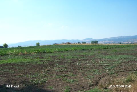
| Location: This site lies east of the city of Bursa; 4 km west of the town of Yenisehir; 3-4 km south of the village of Barçin and about 200 m south of the Yenisehir-Bursa highway. |
| Geography and Environment: The Yenisehir Plain is 4 m high and has a 100 m diameter. There is a freshwater spring very close to the site. Another name for the site is Yenisehir or Bati Höyük. The area is locally known as Üyecek Mevkii; and the mound as Üyecek Tepe. There is a survey point on top of it. The geomorphological and geoarchaeological studies carried out in 2012 indicate that the vicinity of the mound was a swamp-like area [Gerritsen-Özbal 2014:471]. |
| Destruction Details: The mound has been severely damaged due to agricultural activities. There is an artesian well and a tractor road on it [TAYEx 16.7.2000]. |