| ©The Archaeological Settlements of Turkey - TAY Project | ||||||
|
|
||||||
Fistikli Höyük |
||||||
|
|
||||||
| Ages | Maps | Photos | ||||
| Chalcolithic IA 14C |
 |
 |
||||
|
|
||||||
|
Type:
|
Mound | |||||
|
Altitude:
|
485 m | |||||
|
Diameter:
|
m- Direction: | |||||
|
|
||||||
|
Region:
|
Southeastern Anatolia | |||||
|
Province:
|
Sanliurfa | |||||
|
District:
|
Birecik | |||||
|
Village:
|
Mezraa | |||||
|
|
||||||
|
Destruction :
|
Agriculture - Contemporary Settlements | |||||
|
|
||||||
|
TAYEx:
|
Visited - 14/8/2001 | |||||
|
|
||||||
|
Registration State:
|
For detailed registration information please refer to Turkish pages. | |||||
 |
||||||
| Location: The mound lies west-southwest of Sanliurfa; about 4 km south of Birecik; 1.5 km north of Mezraa village. The settlement is situated on the left bank of the Euphrates; about 25 km upstream from Karkamis and within the Karkamis Dam area. The site was first described by Algaze as Zeytinli Bahçe Yani I in the previous publications [Algaze et al.1994:45-46;har.5(45 site no)]. |
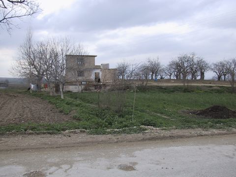
| Geography and Environment: The site is located on the east end of Euphrates flood plain; at a point close to the limestone bluffs which border the plain. It is a small and shallow mound covering an area of 0.5 ha; maximum 4 m high from the plain. Today; the site is covered with pistachio trees. There are contemporary houses on the southern foot and the slopes of the mound are being cultivated. |
| Destruction Details: There are pistachio trees on top; houses on south skirt; fields on west slope and some buildings on other slopes of the mound [TAYEx 14.8.2001]. |