| ©The Archaeological Settlements of Turkey - TAY Project | ||||||
|
|
||||||
Zincirli |
||||||
|
|
||||||
| Ages | Maps | Photos | ||||
| EBA IA |
 |
 |
||||
|
|
||||||
|
Type:
|
Mound | |||||
|
Altitude:
|
580 m | |||||
|
Diameter:
|
m- Direction: | |||||
|
|
||||||
|
Region:
|
Mediterranean | |||||
|
Province:
|
Gaziantep | |||||
|
District:
|
Islahiye | |||||
|
Village:
|
Zincirli | |||||
|
|
||||||
|
Destruction :
|
Illicit Digging - Contemporary Settlements - Attention | |||||
|
|
||||||
|
TAYEx:
|
Visited - 24/8/2001 | |||||
|
|
||||||
|
Registration State:
|
Registered For detailed registration information please refer to Turkish pages. | |||||
 |
||||||
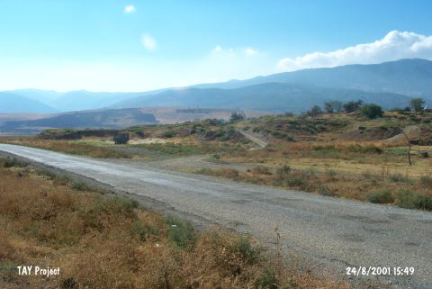
| Location: It is located in the Zincirli Village, north of Islahiye District, west of the provincial district of Gaziantep. |
| Geography and Environment: It is at the intersection near the exit of Fevzipasa train station of Beylan Geçiti, which provides pass over the Amanus mountain range in east-west direction [Özyar 2005:18]; it lies on the west shore of a small swamp in the plain. |
| Destruction Details: Contemporary settlement is partly set on the mound and soil taken from all slopes for building houses. Addition to these illicit digging is destructing the site too [TAYEx 24.8.2001]. |