| ©The Archaeological Settlements of Turkey - TAY Project | ||||||
|
|
||||||
Asagi Salat |
||||||
|
|
||||||
| Ages | Maps | Photos | ||||
| EBA IA |
 |
 |
||||
|
|
||||||
|
Type:
|
Mound | |||||
|
Altitude:
|
490 m | |||||
|
Diameter:
|
m- Direction: | |||||
|
|
||||||
|
Region:
|
Southeastern Anatolia | |||||
|
Province:
|
Diyarbakir | |||||
|
District:
|
Bismil | |||||
|
Village:
|
Yukari Salat | |||||
|
|
||||||
|
Destruction :
|
Natural causes - Contemporary Settlements | |||||
|
|
||||||
|
TAYEx:
|
Visited - 15/9/2001 | |||||
|
|
||||||
|
Registration State:
|
Registered For detailed registration information please refer to Turkish pages. | |||||
 |
||||||
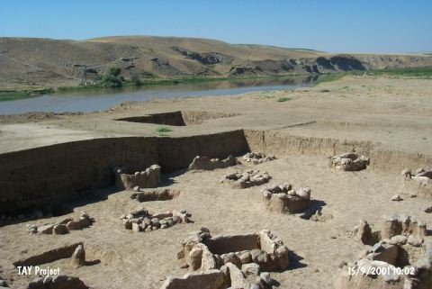
| Location: It is located 3 km south of Yukari Salat Beldesi; 3 km east of the district of Bismil in the province of Diyarbakir. Asagi Salat quarter of the Yukari Salat lies over the mound. The mound is on the bank of the Tigris River; 2 km east of the point where it joins the Salat stream. |
| Geography and Environment: The mound lies on an area fed by Tigris and its tributaries. Between Diyarbakir and Batman; the basin of Tigris is about 500 m high from the sea level. The road of Salat valley passes over Tigris in Asagi Salat and heads towards east and south. The mound; which lies beneath the quarter of Asagi Salat; measures about 150x100 m. It lies on a terrace that is about 3 m above the present river level. The cultural deposit of the site is about 5 m high in the middle section of the modern settlement. The southern section of the mound is destructed by the inundation of Tigris. |
| Destruction Details: The site of Asagi Salat is destructed by contemporary settlement and Tigris River. The quarter of Asagi Salat is settled on the site and southeast portion is eroded by water on a large scale [TAYEx 15.9.2001]. |