| ©The Archaeological Settlements of Turkey - TAY Project | ||||||
|
|
||||||
Kenan Tepe |
||||||
|
|
||||||
| Ages | Maps | Photos | ||||
| Chalcolithic EBA IA 14C |
 |
 |
||||
|
|
||||||
|
Type:
|
Mound | |||||
|
Altitude:
|
530 m | |||||
|
Diameter:
|
m- Direction: | |||||
|
|
||||||
|
Region:
|
Southeastern Anatolia | |||||
|
Province:
|
Diyarbakir | |||||
|
District:
|
Bismil | |||||
|
Village:
|
Kenan | |||||
|
|
||||||
|
Destruction :
|
Agriculture | |||||
|
|
||||||
|
TAYEx:
|
Visited - 15/9/2001 | |||||
|
|
||||||
|
Registration State:
|
Registered For detailed registration information please refer to Turkish pages. | |||||
 |
||||||
| Location: The site is located about 15 km east of the Bismil District in Diyarbakir Province; close to the Diyarbakir-Batman motorway. |
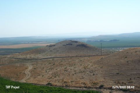
| Geography and Environment: Kenan Tepe is a large multi-period site composed of a tall central mound and extensive lower town stretching off to the northeast of the main mound. The site lies on a natural terrace and the top of the main town is 56.3 m above the Tigris River. The visible mounding extends for 225 m from southeast to northwest and 350 m from southwest to northeast. The Tigris River flows to the east of the mound and the road leading to the mound runs to the west. To the southeast; the village of Sefalik can be seen on a hill. |
| Destruction Details: Kenan Tepe is partly destructed by agricultural activities [TAYEx 15.9.2001]. |