| ©The Archaeological Settlements of Turkey - TAY Project | ||||||
|
|
||||||
Besik / Yassi Tepe |
||||||
|
|
||||||
| Ages | Maps | Photos | ||||
| EBA 14C |
 |
 |
||||
|
|
||||||
|
Type:
|
Mound | |||||
|
Altitude:
|
65 m | |||||
|
Diameter:
|
m- Direction: | |||||
|
|
||||||
|
Region:
|
Marmara | |||||
|
Province:
|
Çanakkale | |||||
|
District:
|
Ezine | |||||
|
Village:
|
Yeniköy | |||||
|
|
||||||
|
|
||||||
|
|
||||||
|
TAYEx:
|
Visited - 22/6/2000 | |||||
|
|
||||||
|
Registration State:
|
Registered For detailed registration information please refer to Turkish pages. | |||||
 |
||||||
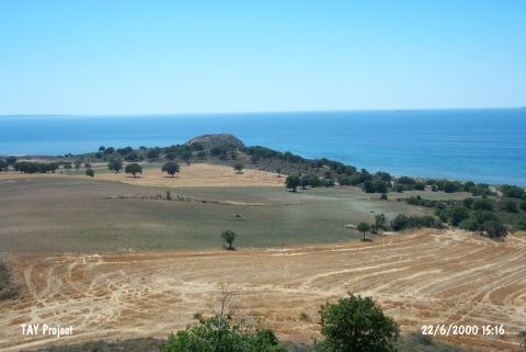
| Location: It lies about 2 km south of Yeniköy; southeast of the Çanakkale Province. It is 7 km far from the Hisarlik Tepesi. |
| Geography and Environment: The mound is located on the north of the Kocaliman Bay; on a small outcrop extending to the Aegean Sea. It is known as Besikburnu or Besika Burnu as well. The bay on its south provides shelter for boats and ships. Papaz stream flows to the northeast. In the vineyards to the east is the cemetery area of the settlement that has been excavated. |
| Destruction Details: |