| ©The Archaeological Settlements of Turkey - TAY Project | ||||||
|
|
||||||
Birecik Baraji Mezarligi |
||||||
|
|
||||||
| Ages | Maps | Photos | ||||
| EBA |
 |
 |
||||
|
|
||||||
|
Type:
|
Cemetery | |||||
|
Altitude:
|
460 m | |||||
|
Diameter:
|
m- Direction: | |||||
|
|
||||||
|
Region:
|
Southeastern Anatolia | |||||
|
Province:
|
Gaziantep | |||||
|
District:
|
Nizip | |||||
|
Village:
|
Merkez | |||||
|
|
||||||
|
|
||||||
|
|
||||||
|
TAYEx:
|
Visited - 20/8/2001 | |||||
|
|
||||||
|
Registration State:
|
For detailed registration information please refer to Turkish pages. | |||||
 |
||||||
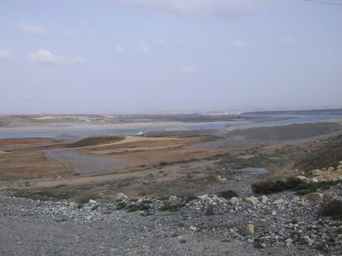
| Location: It lies about 800-100 m southeast of Birecik Dam where the Euphrates coming from the north bends toward the east; 10 km west of Bilecik District of Sanliurfa Province; 9 km east-northeast of Nizip District; about 45 km east of Gaziantep Province. It will not be submerged by the Dam. It has no specific name. The excavators named it after the dam nearby. |
| Geography and Environment: The cemetery starts 30 m far from the southwestern bank of the Euphrates and continues 200 m toward the southwest on a slope rising slightly to the west with a soft inclination. It is 10-15 m high from the river basin. It covers an area of ca. 250 m long in the east-west direction. The graves built into the red clay virgin soil have been completely covered by a 1-1.5 m thick alluvial conveyed by the seasonal streams from the Nizip Plateau in addition to the erosion. The cemetery is in a locked position. |
| Destruction Details: |