| ©The Archaeological Settlements of Turkey - TAY Project | ||||||
|
|
||||||
Büyüktepe |
||||||
|
|
||||||
| Ages | Maps | Photos | ||||
| EBA IA |
 |
 |
||||
|
|
||||||
|
Type:
|
Mound | |||||
|
Altitude:
|
1770 m | |||||
|
Diameter:
|
m- Direction: | |||||
|
|
||||||
|
Region:
|
Black Sea | |||||
|
Province:
|
Bayburt | |||||
|
District:
|
Demirözü | |||||
|
Village:
|
Çiftetas | |||||
|
|
||||||
|
Destruction :
|
Illicit Digging | |||||
|
|
||||||
|
TAYEx:
|
Visited - 26/6/2003 | |||||
|
|
||||||
|
Registration State:
|
For detailed registration information please refer to Turkish pages. | |||||
 |
||||||
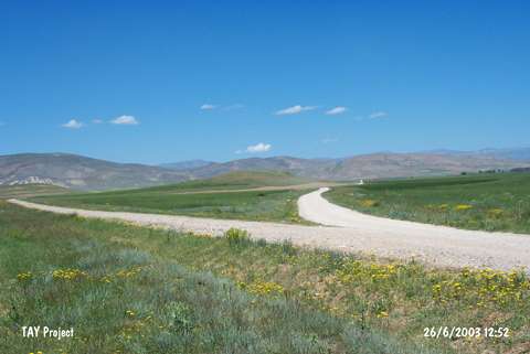
| Location: It is situated 1 km north of the Çiftetas Village; 35 km southwest of the Bayburt Province. It can be reached through a pathway to the village of Çayiryolu; north of the Çiftetas Village. The path lies on the east of the mound [Sagona 1992:fig.1]. The mound is 6 km far from the Çayiryolu Village. |
| Geography and Environment: Büyüktepe consists of two natural hills located in the valley of Bespinar which has very rich water resources. The two hills have a saddle-like connection in between. The one on the south is bigger; 20 m high from the valley and 25x180 m in dimensions. The erosion probably swept the cultural deposit accumulated on the hills; even tough not that thick; for thousands of years and caused the bedrock surfacing in some places [Sagona 1992:305]. |
| Destruction Details: Illicit digging pits were observed. The eastern skirt of the mound has been plowed [TAYEx 26.6.2003]. |