| ©The Archaeological Settlements of Turkey - TAY Project | ||||||
|
|
||||||
Aharköy Hüyük |
||||||
|
|
||||||
| Ages | Maps | Photos | ||||
| EBA IA |
 |
 |
||||
|
|
||||||
|
Type:
|
Mound | |||||
|
Altitude:
|
950 m | |||||
|
Diameter:
|
m- Direction: | |||||
|
|
||||||
|
Region:
|
Marmara | |||||
|
Province:
|
Bilecik | |||||
|
District:
|
Inhisar | |||||
|
Village:
|
Yesilyurt | |||||
|
|
||||||
|
Destruction :
|
Agriculture - Contemporary Settlements | |||||
|
|
||||||
|
TAYEx:
|
Visited - 12/7/2000 | |||||
|
|
||||||
|
Registration State:
|
Registered For detailed registration information please refer to Turkish pages. | |||||
 |
||||||
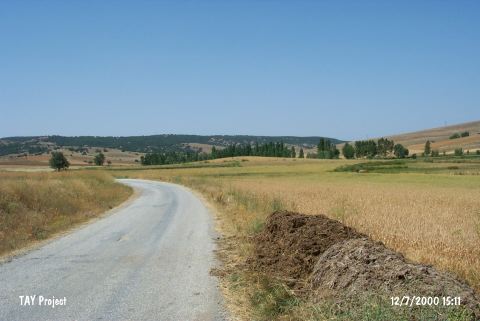
| Location: It is situated 2 km southwest of the Yesilyurt Village (Aharköy); southeast of the Bilecik Province. |
| Geography and Environment: It measures 4-5 m height and 100 m in diameter. It has been partly destroyed (west part) during the installation of the natural gas pipelines. It is one of the small sized mounds of the area. |
| Destruction Details: The half of the mound in the east-west direction has been planted. On the top is the natural gas line pole with the number 506.878-651. The line has cut the southern skirt. The western skirt has also been cut by the Yesilyurt-Oluklu road [TAYEx 12.7.2000]. |