| ©The Archaeological Settlements of Turkey - TAY Project | ||||||
|
|
||||||
Ahlatli Tepecik |
||||||
|
|
||||||
| Ages | Maps | Photos | ||||
| EBA |
 |
 |
||||
|
|
||||||
|
Type:
|
Mound | |||||
|
Altitude:
|
100 m | |||||
|
Diameter:
|
m- Direction: | |||||
|
|
||||||
|
Region:
|
Aegean | |||||
|
Province:
|
Manisa | |||||
|
District:
|
Salihli | |||||
|
Village:
|
Tekelioglu | |||||
|
|
||||||
|
Destruction :
|
Natural causes - Agriculture | |||||
|
|
||||||
|
TAYEx:
|
Visited - 16/9/2000 | |||||
|
|
||||||
|
Registration State:
|
For detailed registration information please refer to Turkish pages. | |||||
 |
||||||
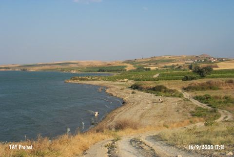
| Location: It lies 800 m west of the Tekelioglu Village; 25 km south of Akhisar; east of the Manisa Province. The settlement stands on a small hill located on a ridge called Ahlatli Tepecik or locally known as Uzun Tarla/Sigir Tarlasi. |
| Geography and Environment: It stands on an outcrop on the southern bank the Lake Marmara [Mitten-Yügrüm 1969:photo on fig 1]. The mound rises with a soft inclination to the south. The size of the settlement is not reported. Even it is not informed whether it is a mound or not. |
| Destruction Details: On the surface of the settlement are olive trees and vineyards. Its northern section facing the lake is being damaged by erosion [TAYEx 16.9.2000]. |