| ©The Archaeological Settlements of Turkey - TAY Project | ||||||
|
|
||||||
Çarkini |
||||||
|
|
||||||
| Ages | Maps | Photos | ||||
| Palaeolithic/Epipalaeolithic Neolithic Chalcolithic |
 |
 |
||||
|
|
||||||
|
Type:
|
Cave | |||||
|
Altitude:
|
300 m | |||||
|
Diameter:
|
m- Direction: | |||||
|
|
||||||
|
Region:
|
Mediterranean | |||||
|
Province:
|
Antalya | |||||
|
District:
|
Merkez | |||||
|
Village:
|
Yagca | |||||
|
|
||||||
|
|
||||||
|
|
||||||
|
TAYEx:
|
Visited - 20/6/2001 | |||||
|
|
||||||
|
Registration State:
|
Registered For detailed registration information please refer to Turkish pages. | |||||
 |
||||||
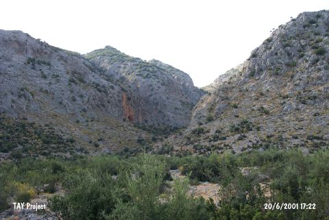
| Location: This cave-site lies southwest of the city of Antalya; 1 km northwest of the Somakli neighborhood of the village of Yagca; 1 km west of the neighborhood of Kocaköy and 2 km south-southwest of the Karain Cave. The location area of the cave is called Öküzkakligi Mevkii. |
| Geography and Environment: The Çarkini Cave lies in the limestone outcrop of Mount Katran; which lies northwest of the city of Antalya. The mouth of the cave faces south. It has been reported that the cave is difficult to reach because it lies 190 m above the terrace and because the entrance is partially blocked by limestone slabs. The height of the cave is questionable but it is reported the cave is 22 m long and 17 m wide. There is a small terrace by the cave entrance. The Kisrakdöllügü River flows beneath. The inhabitants of this cave may have used this stream as a water source. |
| Destruction Details: |