| ©The Archaeological Settlements of Turkey - TAY Project | ||||||
|
|
||||||
Çavdarli Höyük |
||||||
|
|
||||||
| Ages | Maps | Photos | ||||
| EBA |
 |
 |
||||
|
|
||||||
|
Type:
|
Mound | |||||
|
Altitude:
|
1000 m | |||||
|
Diameter:
|
m- Direction: | |||||
|
|
||||||
|
Region:
|
Aegean | |||||
|
Province:
|
Afyonkarahisar | |||||
|
District:
|
Merkez | |||||
|
Village:
|
Çavdarli | |||||
|
|
||||||
|
Destruction :
|
Illicit Digging - Highways, roads, bridges etc. | |||||
|
|
||||||
|
TAYEx:
|
Visited - 2/10/2000 | |||||
|
|
||||||
|
Registration State:
|
For detailed registration information please refer to Turkish pages. | |||||
 |
||||||
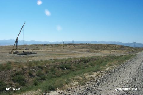
| Location: It lies 3.6 km southwest of the village of Çavdarli; about 12 km east of Afyonkarahisar Province. |
| Geography and Environment: It is located on the lowland formed by the Akarçay Stream. It measures ca. 6 m in height and ca. 200-250 m in diameter. The well located on the north probably supplied the water to the EBA and Roman Period inhabitants. An old river channel passes by the mound. |
| Destruction Details: Illicit digging pits were observed on the eastern part of the mound. The northern skirt was cut by a dirt road [TAYEx 2.10.2000]. |