| ©The Archaeological Settlements of Turkey - TAY Project | ||||||
|
|
||||||
Çengeltepe |
||||||
|
|
||||||
| Ages | Maps | Photos | ||||
| EBA IA |
 |
 |
||||
|
|
||||||
|
Type:
|
Mound | |||||
|
Altitude:
|
1335 m | |||||
|
Diameter:
|
m- Direction: | |||||
|
|
||||||
|
Region:
|
Central Anatolia | |||||
|
Province:
|
Yozgat | |||||
|
District:
|
Merkez | |||||
|
Village:
|
Merkez | |||||
|
|
||||||
|
Destruction :
|
Contemporary Settlements - Attention | |||||
|
|
||||||
|
TAYEx:
|
Visited - 21/7/2002 | |||||
|
|
||||||
|
Registration State:
|
Registered For detailed registration information please refer to Turkish pages. | |||||
 |
||||||
| Location: It lies south of the Yozgat-Sivas motorway; about 500 m east of the Yozgat Province. |
| Geography and Environment: Çengeltepe stands on a volcanic rocky hill at the end of a soft and curved slope. Right across it lays Mercimektepe on the north. Through this low pass between the twin-settlements area runs a motorway. Almost two third of the hill have been destroyed by the brick quarries. |
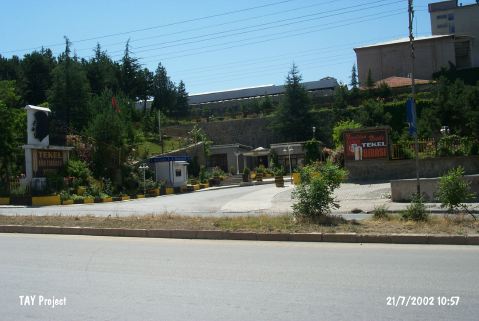
| Destruction Details: The mound has been leveled; Tekel Beer Factory is on it [TAYEx 21.7.2002]. |