| ©The Archaeological Settlements of Turkey - TAY Project | ||||||
|
|
||||||
Çildirin Hüyleri |
||||||
|
|
||||||
| Ages | Maps | Photos | ||||
| Palaeolithic/Epipalaeolithic EBA |
 |
 |
||||
|
|
||||||
|
Type:
|
Mound | |||||
|
Altitude:
|
830 m | |||||
|
Diameter:
|
m- Direction: | |||||
|
|
||||||
|
Region:
|
Eastern Anatolia | |||||
|
Province:
|
Elazig | |||||
|
District:
|
Agin | |||||
|
Village:
|
Yenipayam | |||||
|
|
||||||
|
|
||||||
|
|
||||||
|
TAYEx:
|
Visited - 16/7/2003 | |||||
|
|
||||||
|
Registration State:
|
For detailed registration information please refer to Turkish pages. | |||||
 |
||||||
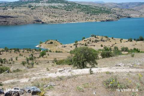
| Location: It is a double mound located in the lowland right above the Arapkir Stream; about 6 km west of the Agin District; northwest of the Elazig Province. Based on the restricted information provided by K. Kökten; it should have been situated west of the Yeniyapanlar Village. |
| Geography and Environment: Below the double mound called Çildirin Hüyleri/Çildirinbasi Hüyleri or Double Hills/Twin Hills; there is a cave called Çildirinini in the Arapkir Stream. K. Kökten reported the presence of a cultural deposit during his 1970 survey. The mound located near the stream and on the edge of the cleft; lying far south was flooded by the Keban Dam. Their location on the edge of a abyss demonstrates that they were easily defended; however the excavation didn't yield any fortification wall supporting this thesis. |
| Destruction Details: |