| ©The Archaeological Settlements of Turkey - TAY Project | ||||||
|
|
||||||
Dedekuyusu / Destepe |
||||||
|
|
||||||
| Ages | Maps | Photos | ||||
| Chalcolithic EBA |
 |
 |
||||
|
|
||||||
|
Type:
|
Mound | |||||
|
Altitude:
|
90 m | |||||
|
Diameter:
|
m- Direction: | |||||
|
|
||||||
|
Region:
|
Aegean | |||||
|
Province:
|
Aydin | |||||
|
District:
|
Merkez | |||||
|
Village:
|
Mesrutiyet | |||||
|
|
||||||
|
Destruction :
|
Agriculture - Contemporary Settlements - Attention | |||||
|
|
||||||
|
TAYEx:
|
Visited - 21/9/2000 | |||||
|
|
||||||
|
Registration State:
|
Registered For detailed registration information please refer to Turkish pages. | |||||
 |
||||||
| Location: |
| Geography and Environment: |
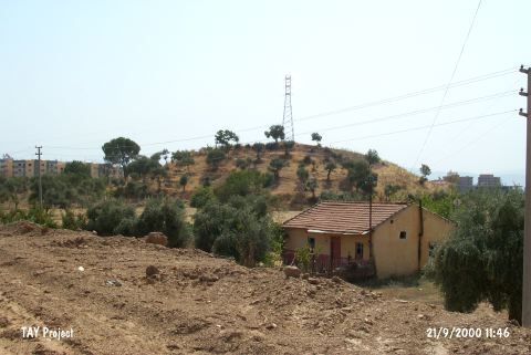
| Destruction Details: The northeastern section of the mound was terraced in order to plant olive trees. An electricity pole was located on the top hill [TAYEx 21.9.2000]. The location area of the mound opened for construction activities after its registration degree dropped to 3 from 1 [Acar 25.12.2006]. |