| ©The Archaeological Settlements of Turkey - TAY Project | ||||||
|
|
||||||
Degirmenlik Mevkii |
||||||
|
|
||||||
| Ages | Maps | Photos | ||||
| Neolithic |
 |
 |
||||
|
|
||||||
|
Type:
|
Flat Settlement | |||||
|
Altitude:
|
14 m | |||||
|
Diameter:
|
m- Direction: | |||||
|
|
||||||
|
Region:
|
Marmara | |||||
|
Province:
|
Çanakkale | |||||
|
District:
|
Eceabat | |||||
|
Village:
|
Yalova | |||||
|
|
||||||
|
Destruction :
|
Contemporary Settlements - Attention | |||||
|
|
||||||
|
TAYEx:
|
Visited - 20/6/2000 | |||||
|
|
||||||
|
Registration State:
|
Registered For detailed registration information please refer to Turkish pages. | |||||
 |
||||||
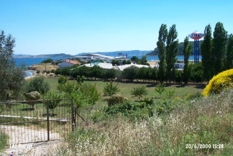
| Location: This site lies north of the city of Çanakkale; 8 km northeast of the town of Eceabat and approximately 100 m south of the Akbas military cemetery. |
| Geography and Environment: It lies on a sheer cliff by the sea; on the southern side of the Eceabat-Gelibolu road. The area is named after a mill that was here previously. The finds were found in a 100x50 m area near the Dardanelles on the flanks of a large stone outcrop facing away from the sea. The survey code of the site is H 2 / 12. |
| Destruction Details: The settlement is in the lands of Anati Bosfor mussel factory and has been completely leveled [TAYEx 20.6.2000]. |