| ©The Archaeological Settlements of Turkey - TAY Project | ||||||
|
|
||||||
Demircihöyük |
||||||
|
|
||||||
| Ages | Maps | Photos | ||||
| Neolithic Chalcolithic 14C |
 |
 |
||||
|
|
||||||
|
Type:
|
Mound | |||||
|
Altitude:
|
870 m | |||||
|
Diameter:
|
51 m- Direction: N-S | |||||
|
|
||||||
|
Region:
|
Central Anatolia | |||||
|
Province:
|
Eskisehir | |||||
|
District:
|
Çukurhisar | |||||
|
Village:
|
Zemzemiye | |||||
|
|
||||||
|
Destruction :
|
Agriculture - Highways, roads, bridges etc. | |||||
|
|
||||||
|
TAYEx:
|
Visited - 29/6/2002 | |||||
|
|
||||||
|
Registration State:
|
For detailed registration information please refer to Turkish pages. | |||||
 |
||||||
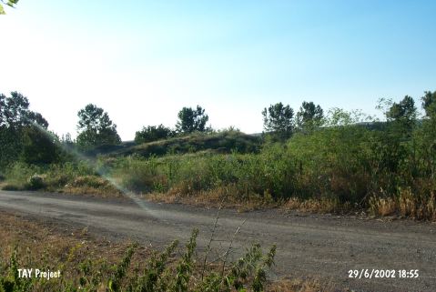
| Location: This site lies 25 km west of the city of Eskisehir; northwest of the town of Çukurhisar and along the highway between this town and the village of Poyra; before the turn-off to Zemzemiye. |
| Geography and Environment: The mound which lies in the western part of the Eskisehir Plain; located along the Anatolian shore of the Sea of Marmara; remains partially beneath the alluvial fill of the mound. It is 80 m in diameters and 5 m above the level of the plain today. Test trenches and deep soundings revealed that the actual dimensions of the mound are much larger. It has partially been cut by the Çukurhisar-Poyra highway. |
| Destruction Details: The trenches are filled with pebbles at the mound which has been excavated before. The north-northwest skirt is cut by a field and south; northeast skirts are cut by road [TAYEx 29.6.2002]. |