| ©The Archaeological Settlements of Turkey - TAY Project | ||||||
|
|
||||||
Dorak |
||||||
|
|
||||||
| Ages | Maps | Photos | ||||
| EBA |
 |
 |
||||
|
|
||||||
|
Type:
|
Cemetery | |||||
|
Altitude:
|
300 m | |||||
|
Diameter:
|
m- Direction: | |||||
|
|
||||||
|
Region:
|
Marmara | |||||
|
Province:
|
Bursa | |||||
|
District:
|
Mustafakemalpasa | |||||
|
Village:
|
Dorak | |||||
|
|
||||||
|
|
||||||
|
|
||||||
|
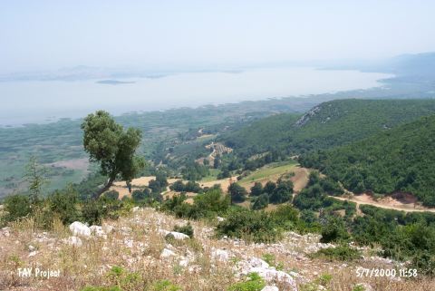
TAYEx:
|
Visited - 5/7/2000 | |||||
|
|
||||||
|
Registration State:
|
For detailed registration information please refer to Turkish pages. | |||||
 |
||||||
| Location: It stands on a slope near the village of Dorak; south of Uluabat Village; former name Apolyont; northeast of the Mustafakemalpasa District; west-southwest of the Bursa Province. |
| Geography and Environment: Finds cited as Dorak in the archaeological literature are exhibited neither in any museum nor any private collection. All the information given herein below is based on the limited data about the graves and figures drawn by J. Mellaart at Anna Papa's house in Karsiyaka; Izmir. The graves are claimed to be located on an outcrop extending to the lake. |
| Destruction Details: |