| ©The Archaeological Settlements of Turkey - TAY Project | ||||||
|
|
||||||
Findik Kayabasi |
||||||
|
|
||||||
| Ages | Maps | Photos | ||||
| Neolithic |
 |
 |
||||
|
|
||||||
|
Type:
|
Flat Settlement | |||||
|
Altitude:
|
940 m | |||||
|
Diameter:
|
m- Direction: | |||||
|
|
||||||
|
Region:
|
Aegean | |||||
|
Province:
|
Kütahya | |||||
|
District:
|
Merkez | |||||
|
Village:
|
Findikköy | |||||
|
|
||||||
|
|
||||||
|
|
||||||
|
TAYEx:
|
Visited - 3/7/2004 | |||||
|
|
||||||
|
Registration State:
|
Registered For detailed registration information please refer to Turkish pages. | |||||
 |
||||||
| Location: This site lies northeast of the city of Kütahya; approximately 3 km northeast of the village of Sabuncular-Findik; at the border of the provinces of Kütahya and Eskisehir. The site lies 500 m south of the Eskisehir-Kütahya railroad tracks. |
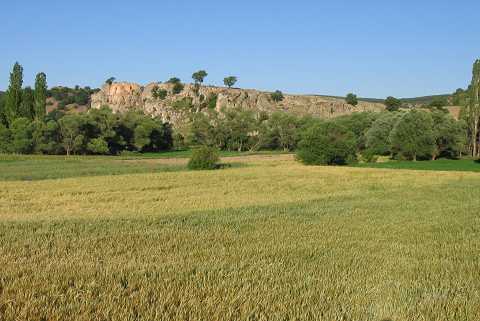
| Geography and Environment: The site lies on the northern side of a rocky outcrop. Efe believes that this slope; now very steep; was previously terraced [Efe 1995b:106]. The rocky areas rise steeply out of two sides of the cliff. The eastern rocks have rooms; probably Byzantine in date; carved into them. The site lies south of Findik Stream or Asi Stream which is a tributary of Kargin Stream. |
| Destruction Details: |